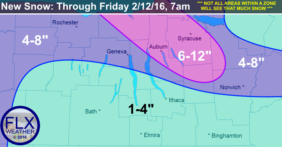
A widespread couple of inches will fall Wednesday along a cold front, followed by areas of lake effect through Thursday.
Snow is already ongoing across the Finger Lakes Wednesday morning and will continue throughout much of the day as a cold front slides east through the area. Most areas should see a couple of inches of snow from this system by this evening.
Most of the 1-4″ shown in the light blue area across the southern Finger Lakes will fall by Wednesday evening.
Temperatures today will only rise from the upper 20s to the low 30s before cooler air starts to stream in. By Thursday morning, most locations will be in the teens. Very little rise in temperature is expected Thursday, with temperatures remaining in the teens.
The winds will become gusty Thursday as well. Some areas, especially across the southern Finger Lakes, could gust over 30 mph at times. This will send wind chills to near or below zero, even during the afternoon hours on Thursday.
Lake effect snow will organize and become strong within its bands Wednesday night into Thursday, thanks to the fresh supply of cold air. Areas along and north of I-90 should see a moderate snowfall as the bands traverse back and forth across the region.
Wayne County, the northern 2/3rds of Cayuga County, Onodaga County and northern Cortland County could locally see up to a foot of snow as lake snows off of Lake Ontario focus in these areas Thursday.
Thursday night, winds will begin to turn more southerly. Lake snows should lift north, but some snow off of Lake Erie, in combination with another cold front, will be possible into Friday. Temperatures Friday will rise into the upper 20s ahead of the cold front.
However, even colder air lurks behind the front. Temperatures will drop to near 0 degrees by Saturday morning and will struggle to get much warmer during the day. Strong winds will create dangerous wind chills, possibly as low as -25 degrees at times. Some limited lake effect snow southeast of Lake Ontario may be possible, but should end on Sunday.
Confidence is growing in some sort of storm system in the general region on Tuesday. It is too early to tell whether this storm would bring snow, rain, or a mix, or even if it will miss the Finger Lakes. Stay tuned for updates over the coming days and beware of weather hype!


Katherine Lockwood
Thank you for your hype-free forecasts!