Low pressure over Indiana will slowly drift northeast, keeping the Finger Lakes showery into early next week.
Showery, But Not Substantial

A stream of moisture from the Atlantic is pumping rain into New Jersey and eastern Pennsylvania. This stream of rain is pointed right at the Finger Lakes, yet our weather today should be a bit showery at best with very low amounts of rain.
Unfortunately, our region is falling victim to a downsloping effect that is preventing rain from reaching our area. This is the same phenomenon that is responsible for the semi-arid climate across much of the western United States.
As moisture rich air from the ocean moves inland, it is forced upward by rising elevations- in this case, the Poconos of eastern Pennsylvania. As the air rises, it cools. Cooler air cannot hold as much moisture, so the moisture falls out as rain.
As the air traverses over the higher elevations, it sinks down the other side. The sinking air warms and dries and precipitation is much harder to come by. This is occurring between the Finger Lakes and the higher elevations to the southeast and is resulting in yet another miss of substantial rain for our parched region.
Disturbances Rotate Through
Showers will continue on and off through the weekend and into early next week as low pressure over Indiana slowly drifts northeast.
Disturbances in the atmosphere are rotating around this low pressure system, resulting in an enhancement of the showers in those areas. In the map at the start of this blog, I have circled the yellow dashed lines which represent these disturbances.
These disturbances are very subtle features in the atmosphere. As such, they are hard to detect and predict more than a day or so in advance.
However, based on the current projections, it appears that the timing of these disturbances, and thus our best chances for rain this weekend, are as follows.
One such disturbance is moving through Friday morning. Another is possible overnight tonight. The next one is expected Saturday night, and again later Sunday.
Matthew Strengthens Rapidly in Carribean

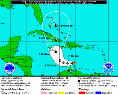
The current forecast track, while somewhat uncertain, takes Matthew very close to Jamaica by Monday morning. By this time, Matthew should be a major, category 3 hurricane with winds of 120 mph. However, Matthew could become even stronger than the current official forecast has.
After striking Jamaica and Cuba, Matthew should move north over the Bahamas. However, there is very little confidence in the track and strength of Matthew, and those along the East Coast should continue to be very watchful.


Showers persist across the FLX this weekend – FingerLakes1.com
[…] Read more from FLXWeather.com […]