The majority of the Finger Lakes only saw between 10-50% of the normal amount of rainfall during the month of June.
With no end in sight to the excessively dry weather across the Finger Lakes, I have decided to post a weekly drought report on Thursdays. I will continue to run this weekly feature as long as the drought persists and as long as there are no other major weather stories (severe weather, extreme heat, etc.) to discuss on a Thursday.
Recent Rainfall History

Rain fall was limited once again across the Finger Lakes during the last week. Most areas saw insignificant amounts under a quarter-inch.
Just to the east of the Finger Lakes, thunderstorms on Tuesday brought some beneficial rain to parts of Central and eastern New York. Many areas got around an inch of rain. A few areas saw too much rain too fast and had to contend with some flooding.
A few places in western New York also managed to get over a half-inch of rain.
Since today is the last day of June, and no rain is expected in the Finger Lakes, we can draw some conclusions about the month as a whole. The map at the top of this blog shows what percentage of the normal amount of rain fell during the last 30 days.
The bright red area in the heart of the Finger Lakes is only 10-25% of the normal rain. The vast majority of the remainder of the Finger Lakes saw between 25-50% of their normal rain (orange areas).

Drought Status
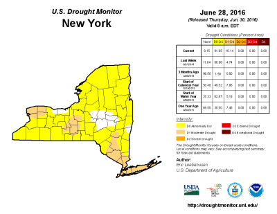
This week’s US Drought Monitor report shows the entire Finger Lakes in at least D0- Abnormally Dry status. As I suspected last week, some D1- Moderate Drought has shown up in the Finger Lakes as well. All of Tompkins county, along with parts of Schuyler, southeast Seneca, southern Cayuga and southwestern Onondaga county have been placed in the Moderate Drought designation.
As a whole, over 91% of New York is now at least considered Abnormally Dry, an increase of about 3% over last week. More significant is the increase in Moderate Drought status. These areas increased nearly four-fold, from 4.74% to over 16%.
The current drought still remains less intense than the July 2012 drought. During that drought, about one-third (33.25%) of New York state was classified as a Moderate Drought. The most significant period of drought since weekly data became available in 2000 was during 2001 and 2002. There were a number of weeks during these years which saw parts of the state in Severe (D2) and even Extreme (D3) drought.
Rainfall Outlook
Over the next 7 days, there is primarily one chance for rain, which will come on Friday, July 1. A cold front will bring showers and some thunderstorms to the area. The chances for substantial rain will not be equal across the region, however. For areas roughly from Seneca Lake and west, the atmosphere will not be overly favorable for thunderstorm development. As a result, precipitation in these areas will be limited to scattered rain showers. Most places in the western Finger Lakes, therefore, will see less than a quarter inch of rain. This will do little to help with the overall drought conditions.
The eastern Finger Lakes will have a bit better of a chance for heavier rain. Thunderstorms will be more likely to develop over these areas. Thunderstorms will be scattered, so many areas will probably end up like the western Finger Lakes with only light rain amounts. A few areas, however, could see upwards of a half inch or more. While certainly not drought-busting, that would at least slow the progression of the drought a little bit.
Areas east of the Finger Lakes once again will have the best chance for substantial rain fall. Coming on the heels of this past week’s rain, some significant improvement in the drought may be made east of I-81. Still, unless such a pattern of weekly rain continues, even these areas will remain abnormally dry.
To make matters worse, temperatures will be on the rise next week, with 80s very likely and a few chances at 90 degrees. The humidity may come up towards the middle of the week, which is marginally better than the dry heat which sucks moisture out of the ground and vegetation.

