Lake Effect Snow Thursday
Lake effect snow off of Lake Erie has moved into the Finger Lakes overnight and will continue to wobble to and fro across the area on Thursday.
The band of lake effect is not expected to remain in a single spot today. This morning, the band is moving back north after sinking well south into the Finger Lakes overnight.
The northern Finger Lakes will see the most lake effect snow this morning before snows head back south for a time this afternoon.

Most of the snow will be light, but a few brief squalls will be possible, especially along and west of I-390.
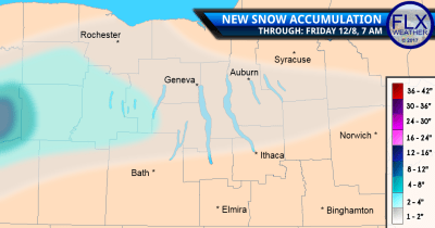
The snow map I published yesterday and am embedding here again still looks good.
Most of the region will only see a coating to perhaps an inch or two. Most of this will fall across the central and northern Finger Lakes with little to no snow accumulation across the Southern Tier.
After a few more flurries and squalls this evening, the lake effect will head north as winds turn back to the southwest.
Temperatures today will mostly be in the mid 30s, though areas west of I-390 and in the higher elevations of the eastern Finger Lakes may only see low 30s.
Quiet, But Cool Friday & Saturday
Winds will continue to turn more southerly Friday and Saturday, keeping any lake effect well north and west of the Finger Lakes.
Instead, Friday should be a rather sunny day. Saturday, too, will start with some sun before clouds increase during the afternoon.
Despite the south winds, temperatures will not be very warm though.
Friday will get off to a rather chilly start with morning lows ranging from the mid 20s across the northern areas to the upper teens in the Southern Tier.
Highs Friday afternoon will only reach the low 30s for most places with just a couple areas making a run at 35 degrees.
Saturday will be a touch warmer. After starting with lows in the 20s, afternoon highs should reach the mid and upper 30s. That is actually very close to the normal high for this point in December.
More Significant Cold Gearing Up
A series of small, fast-moving “clipper” systems will target the Finger Lakes later in the weekend and into next week.
Each of these systems will act to reinforce the cold air, resulting in well below normal temperatures by the second half of next week.
Temperatures Sunday will struggle to get out of the 20s. Monday will be a touch warmer with low and mid 30s, but the rest of the week will have highs in the 20s and even teens.
The amount of snow and lake effect that these systems will bring remains much less certain.
Those details will have to be worked out one at a time in the 24-48 hours preceding each system.


Light snow possible in parts of the FLX on Thursday – FingerLakes1.com
[…] Read more from FLXWeather.com […]