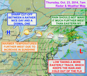
The weather for the Finger Lakes will be much nicer today than was originally thought. Instead of tracking northeast to a position off the coast of northern New England, the low pressure that has been impacting our weather is heading east, away from the coast.
Rain, and thick clouds from the low, are only as close as eastern New York this morning and they will not likely make any further progression west. That isn’t to say that a stray shower may not make it into the I-81 corridor, but the chances of that are pretty small.
All in all, it won’t be a bad day today at all.

Sunshine should be more of a factor in our weather, with western parts of the Finger Lakes enjoying quite a sunny day. Areas further east will see a mix of sun and clouds.
With the extra sunshine, temperatures will be warmer further west as well, but even the eastern Finger Lakes should make it into the low 50s.
Partly cloudy to mostly clear skies tonight will allow temperatures to mostly drop into the upper 30s before a sunny, seasonable Friday with highs in the upper 50s.
Most of Saturday looks pleasant, with highs pushing into the low 60s. Some afternoon showers will be possible as a quick moving front slides through. A few showers will also be possible on Sunday as a second disturbance moves by.
Next week is generally looking mild, with highs possibly even approaching 70º on Tuesday!
[donate_button button_type=”default” title=”Please support Finger Lakes Weather!” style=”wdf-basic”]

