We are starting to get to the point in the evolution of this storm where looking at current conditions and radar is a crucial part of the forecasting. No longer do we have to rely on model data- now we can compare what the models show to what is actually happening and adjust accordingly.

All in all, the storm is behaving as expected. Precipitation is breaking out along the East Coast as the low begins to organize. The models seem to be in fairly good agreement through this evening on what to expect. The forecast becomes more difficult after that as the models try to handle the stalled out system and the timing and location of impulses of energy rotating around it.
Here is a break down of what to expect when, as well as the changes I’ve made to the forecast since last night.
- During the day Tuesday, expect dry conditions from I-81 west. Rain will move into the I-81 corridor this evening before it changes to snow.
- Snow will gradually overspread the Finger Lakes after midnight, but most of the snow will be during the day on Wednesday.
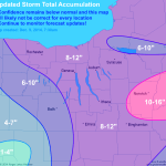
- I shrunk the 10-16″ area east of the Finger Lakes to account for more rain and mixed precipitation. Some higher elevations in northeast Pennsylvania will exceed the 8-12″ though.
- I expanded the 8-12″ area into the northern Finger Lakes. I had highlighted this area last night as being on the high end of 6-10″, but I think with some enhancement from Lake Ontario, some places may even exceed a foot by the time it is mostly done Thursday evening.
- I still think the Mohawk Valley near Oneida Lake sees less than its surrounding areas as warmer air holds on a bit longer, delaying the change over to snow.

Please continue to monitor the situation as this storm evolves, and be safe!

