The drought status map for the Finger Lakes remains unchanged this week.
Drought Status
The drought in the Finger Lakes persists, with no changes made by the US Drought Monitor in their weekly update.

Level 3 (Extreme) Drought continues across a stretch of the northern Finger Lakes and along the southern tips of Keuka, Seneca and Cayuga lakes. The remainder of the area is in a Level 2 (Severe) drought.
There was a slight expansion of the No Drought area to the east. Across New York, 14.08% of the state has no drought conditions, up from 12.57% last week.
There were a number of questions last week about how these maps are generated. The Drought Monitor, which Finger Lakes Weather is in no way affiliated with, generates these maps from a wide variety of data sources and trained spotters.
It is very important to remember, however, that nature does not fall nicely into man-made zones and maps. Conditions will vary locally within these zones. Areas that are listed as D2, but are near the D3 areas will have worse conditions than those in a D2, but near a D1 area. The map is a visual guide, not an exact measurement.

Recent & Expected Rainfall
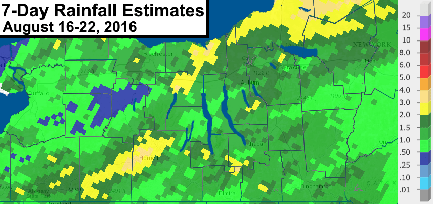
Rainfall during the past week primarily fell on Sunday. A cold front brought a widespread area of moderate to heavy rain.
Many locations in the Finger Lakes saw between one and two inches from this event. Some areas even exceeded two inches.
This was also a prolonged event, which gave the rain some extra time to soak into the ground.

Unfortunately, it does not appear that any similar events are on the horizon.
Scattered showers and thunderstorms are ongoing Thursday morning, and some more generally light precipitation can be expected Thursday night into early Friday.
The next chance for heavier rain will come as thundery downpours Sunday evening. Much of next week, however, looks dry.
Over the last 30 days though, there has been some improvement with generally near or above normal precipitation. However, this is only a minor improvement. Over the last 180 days, much of the Finger Lakes is 6 to 12 inches of rain below normal.
Tropical Relief?
All eyes continue to watch a strong topical wave as it approaches the Bahamas over the next couple of days. This system only needs a bit more organization to become Tropical Storm Hermine.

Confidence is moderately high that this system will make its way towards southern Florida this weekend before likely heading into the Gulf of Mexico. The strength and organization of the system is questionable, but it at least has some potential to become a hurricane.
Beyond southern Florida, the track of this system remains uncertain. The two favored possible tracks seem to be either up the west coast of Florida, or a more westerly track towards the central Gulf Coast.
While it does remain a possibility that rain from this system could eventually make it to the Finger Lakes, especially with a more western Gulf of Mexico track, it seems unlikely that Hermine will bring us any relief.
Nearly all models have a strong high pressure over the Great Lakes region that effectively deflects the system eastward towards the Carolinas. This would be towards the end of next week though, so there is plenty of time for things to change.
A moderate, soaking rain would certainly be beneficial, but any tropical systems that move into the area bring a risk for more rain than we bargained for. Stay tuned.


Drought in the Finger Lakes continues; rain does little to ease deficit – FingerLakes1.com
[…] Read more from FLXWeather.com […]