


Cold Front, then Lake Effect
An active weather pattern will make each upcoming day a bit different from the day before.
Early this morning, a warm front moved through the region with an area of rain and snow. That precipitation is now to the east and a narrow wedge of warmer air is moving into the region.
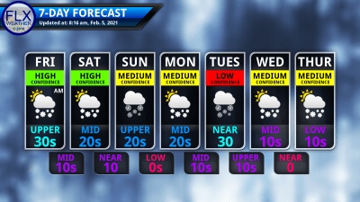
Temperatures will get to the mid and upper 30s this morning and a few places may still reach 40 degrees. The cold front is hot on the heels of the warm front, though, so our window for warming is limited.
Already, at 7 AM, temperatures are starting to fall along the shore of Lake Erie as the cold front enters New York State. Most places should reach their high temperature between 10 AM and 1 PM. From there, it will be a steady drop back through the 30s with 20s by this evening.
A few snow showers may accompany the cold front, but for the most part, the rest of today should be dry with some sunshine poking out between clouds.
South winds will gust over 30 mph at times this morning. Once the cold front moves through, winds will turn to the southwest and gusts will drop below 30 mph, except for the Buffalo to Rochester corridor, where winds will actually increase.
Lake snows will develop off Lake Erie this evening, but stay north and west of Batavia and Rochester. Overnight, winds will shift slightly and Lake Eire will send a few bands of snow eastward across the Finger Lakes as it reorganizes itself. Only minor accumulations are expected.
A consolidated band of snow off Erie is likely throughout Saturday, mainly impacting areas along and north of the Route 20 corridor west of I-390, Monroe County, Wayne County, and northern Cayuga County. A few inches may fall across these areas on Saturday.
To the south, most of the Finger Lakes will have a mix of clouds, some sun, and just an occasional flurry.
Morning lows tomorrow will range through the teens with afternoon highs in the low to perhaps mid 20s.

Parade of Weather Systems
Confidence is now increasing substantially for Sunday’s weather with most models in good agreement with the evolution of the weather pattern.
Two systems will race southeast from western Canada today. One system will move towards the Great Lakes, while the other tracks all the way into the Deep South. From there, low should develop off the coast of the Carolinas and track to the northeast.
This low and the system moving into the Great Lakes should not completely phase up, with the coastal low staying ahead of the Great Lakes system. No snow from the coastal low is expected to make it to the Finger Lakes, but some snow showers on Sunday are still likely as the Great Lakes energy passes through. Accumulations should be on the order of an inch or less.
Temperatures have an outside chance to sneak into the 30s Sunday between these systems, but highs in the mid and upper 20s are more likely.
Monday now looks fairly quiet with just a few lake flakes in the northeastern Finger Lakes. Outside of those, some breaks of sun will be possible. Temperatures will mostly stick to the low 20s.
A moderately strong low will track nearby on Tuesday. This path is still uncertain enough where a mix of precipitation types may be possible. More likely, though, most of what falls will be snow with a few inches possible.
Lake effect should flare up behind this system as temperatures drop further. High temperatures from Wednesday through Saturday will be in the teens, and a few places may not even reach 10 on Thursday and Friday.
Lake snows will be most common in the northern and northeastern Finger Lakes, but there may be times the snow pushes further north. Timing these fluctuations is something that needs more time to resolve.
More Information:
» Finger Lakes Weather Radar
» Zip Code Forecasts
Get the latest forecasts delivered to your inbox automatically. This is the best way to ensure you are always seeing the newest information. Subscribing is easy, free, and secure.
 This graphic represents an average over the entire Finger Lakes region. Localized variations should be expected.
 Stay Updated With Email Alerts
