Feeling the Season
Today is the official start of Spring, and the weather in the Finger Lakes will make a quick turnaround to the new season after a cold day yesterday.
Factoring in the wind, some places never felt warmer than the mid and upper 10s on Sunday. However, those cold northwest winds have been replaced by warming southwest winds, and today will feel much more like the new season that it is.
Aided by bright, sun-filled skies, the southwest wind will push temperatures in to the upper 40s to near 50 degrees today. The winds will be much gentler, with speeds of 5-10 mph and gusts of 20-25 mph.
A few thin clouds will begin to enter the region late this afternoon, with a period of clouds overnight. A stray shower or flurry cannot be totally ruled out, but these will be very few and few between.
Southwest winds will persist overnight, only allowing temperatures to drip into the upper 20s and low 30s.
There will be more clouds on Tuesday, but also still some breaks of sunshine. Temperatures will add a couple more degrees as southwest winds continue for most of the day, resulting in most places getting into the low 50s.
Temperatures will hold in the low 30s Tuesday night as clouds increase and thicken. Wednesday will be mostly cloudy, but no precipitation is expected. Light south and southwest winds will continue to nudge temperatures higher, with widespread mid 50s likely even without the sunshine.

Unsettled Late Week Weather
A cold front will move through the region on Thursday.
Out ahead of the cold front, temperatures will remain warm. Morning lows on Thursday will only reach the mid 40s, getting the daytime temperatures off to a head start. If the cold front is delayed long enough, and if some sunshine can manage to poke its way out between the clouds, upper 50s will be likely at a minimum.
Rain will eventually move through the area, preceded by blustery south and southwest winds. By the evening, winds will be out of the northwest and cooler air will start to move in.
The front should stall out on Friday, though the trends in the models are for this to happen well to our south across Pennsylvania. This will put us on the cooler side of the front, but also far enough away that precipitation is not expected at this time.
Temperatures on Friday should manage to break into the low 40s as long as any precipitation stays well to the south.
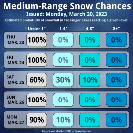
Low pressure is expected to move into the area on Saturday. The fine details this far out are uncertain and subject to change, but some morning snow may be possible before rain becomes more likely in the afternoon.

This system should be out of the area by Sunday, though some blustery winds may remain behind. Nonetheless, temperatures should warm on Sunday with highs possibly even in the upper 40s.
Next week looks active with several chances for precipitation. Daytime temperatures are mostly expected to be in the 40s resulting in rain, but nighttime temperatures will remain cool enough for some snow chances.
More Information:
» Finger Lakes Weather Radar
» Zip Code Forecasts
» Get the FLX Weather Mobile App
This graphic represents an average over the entire Finger Lakes region. Localized variations should be expected.


