


For the majority of the Finger Lakes and the majority of the day, it will just be another quiet winter’s day.
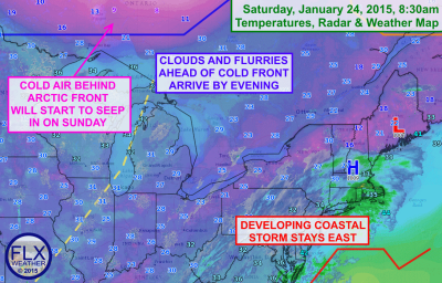
Clouds will likely hang tough around the region, with a major winter storm to our southeast and a cold front dropping south towards us out of Canada. That said, there is a narrow window between these two systems that could bring a few breaks of sun, especially over the western Finger Lakes.
Any snow showers that were in the southern and eastern parts of the Finger Lakes this morning from the coastal storm are pulling away. Most of them weren’t even reaching the ground to begin with.
Temperatures will likely climb just a few degrees today from the upper 20s to the low 30s, especially in any areas that see a little sun.
By this evening, snow showers out ahead of the cold front should move into the region and persist through the night. Accumulations will mostly be less than an inch.
Most of the snow showers should be done by Sunday morning, though some lake effect may keep flurries around into the late morning for the eastern Finger Lakes. Temperatures will slowly fall through the 20s during the day on Sunday.