Between Systems Thursday
The Finger Lakes is situated in a lull between two storm systems on Thursday, but by Friday, snow, some heavy, will return to the Finger Lakes.
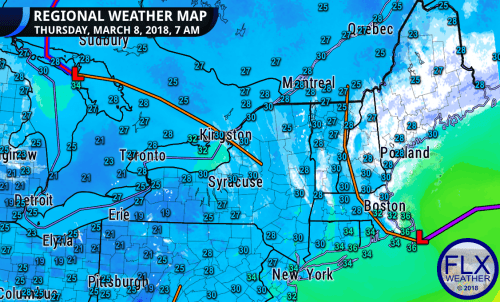
Low pressure remains parked over the Great Lakes to our west, while yesterday’s nor’easter continues to slowly churn up the coast of New England.

Between these two systems, an area of slightly drier air has wedged into the Finger Lakes.
Clouds will remain thick today and some on and off flurries will still be likely, but no accumulating snow is expected.
Temperatures will rise through the 20s this morning to a high in the low 30s this afternoon.
The weather pattern over the North Atlantic is blocked up, meaning the nor’easter will not head out to sea anytime soon. Instead, this low will track north into Maine, then spin back towards the west over southern Canada.
As this happens, moisture will return to the Finger Lakes from the north.
Snowy, Windy Friday
Snow will move back into the Finger Lakes overnight tonight as the moisture returns.
At first, the snow should be widespread and generally light. Some heavier snow will be possible downwind of the Great Lakes and over higher elevations, especially in the eastern Finger Lakes.
By the afternoon, the lake enhanced squalls should start to become stronger and more consolidated.
[wp_ad_camp_1]The strongest band is expected to form a connection to the Georgian Bay off of Lake Huron, which could lead to snowfall rates of an inch an hour or more from Rochester into the eastern Finger Lakes during the evening commute.

This connection is expected to be brief and the snow will shift north of the Finger Lakes for Friday evening and Friday night. A few flurries and the occasional squall will remain possible despite this.
Lighter snow squalls will move back south into the area Saturday morning and will gradually dissipate Saturday afternoon.
As is usually the case when the Great Lakes are involved, snow amounts will vary greatly across the region and over small areas.
The highest accumulations are expected over higher elevations south of Syracuse. A combination of the higher terrain and favorable location should give these areas more snow than nearby places such as Auburn and Syracuse. Over 6 inches could fall locally.
Most of the northern Finger Lakes should see a couple inches, while areas further south may only see a coating of snow.
In addition to the snow, winds will gust over 30 mph on Friday and Saturday. This will cause blowing and drifting snow, which will make travel locally difficult.
The weather should calm down for Sunday, with mostly cloudy skies but nothing more than a stray flurry to contend with.
[wp_ad_camp_1]

John Gregoire
I noticed that the NWS has finally recognized Finger Lakes altitude! On their current snowfall prediction maps, they shade in the high ground in Schuyler/Seneca between Seneca and Cayuga Lakes and assign it a number greater than the surrounds for snowfall. So where you have me at one inch, it would reflect two or more which is more accurate. john
Meteorologist Drew Montreuil
I think the difference in our maps this time is that I don’t expect much if any in the way of lake enhancement/lake effect that far south. Yes, I think your higher elevation will see more than the surrounding areas, but the difference will be quite minor this time.
The south edge of the lake effect is always tricky in these northwest wind cases. I feel like the models and forecasts (mine included) always bring the accumulations too far south, so I tried to account for that this time. We will see!