


Winter Storm Tonight
A relatively quick but intense winter storm will impact the area tonight after starting as some light snow during the daytime hours.
Finger Lakes Weather is primarily supported by the generosity of those that use this service. This support makes it possible for me to give frequent, detailed updates during hazardous weather. By the end of this week, I will have published blog posts on 25 of the last 26 days and answered dozens of personal questions one-on-one behind the scenes. I am proud to offer these services, but do need your continued support to keep this pace sustainable.
Before Reading On…
Please consider a monthly or one-time donation to help Finger Lakes Weather. Thank you for supporting Finger Lakes Weather!
Monthly Donation
Single Donation
The first wave of snow will move through the area this morning and into the early afternoon. This snow may cause minor travel delays as it drops a general inch or two across the region.
The steadiest of this snow will move in between 9-11 AM and depart between 12-2 PM, lasting about 3 hours for any given location.
Behind the steadier snow, on and off snow showers will continue into the afternoon and early evening with little to no additional accumulation.
Heavier snow will start to move in after 8 PM, starting in the southwest and expanding northeastward. The snow will quickly become heavy, with a few hours of snow for all locations. After midnight, sleet and freezing rain will enter into the picture for roughly the southeastern half of the region.
Most areas that see a change over will continue to experience icy precipitation until dry air abruptly ends the storm early Tuesday morning. Since my post yesterday, models have shifted further north and west with the sleet, coming closer to the ideas I published yesterday.
I have made some fine-tuning adjustments to my snow map. Namely:
- I added a 12-16 inch range from Rochester westward, where some lake enhancement off Lake Ontario may just nudge totals over a foot.
- I nudged the 8-12 inch range slightly to the east to better match the models now that they, too, are bringing the sleet into the same areas I suspected yesterday.
- I also pushed the 2-4 inch range away further away from the Finger Lakes to account for a slower change over to icy precipitation across the Southern Tier.
For most areas, these changes either resulted in no change to the forecast, or an upward adjustment of just an inch or two.
Travel will be treacherous once the snow starts tonight and into Tuesday morning, even as the precipitation ends. Areas that see lower snow amounts will see more ice and do not mean that the impacts will be less.
Snow showers will linger across the far western Finger Lakes during the midday and early afternoon hours. These will gradually spread east during the afternoon, transitioning to some lake effect from Wayne to Cortland county Tuesday evening. An additional inch or two may fall in the lake effect areas Tuesday night.
Temperatures will rise to the mid 20s today, then initially drop back to near 20 this evening.
By Tuesday morning, upper 20s will be possible across the southeastern Finger Lakes as the warmer air moves in, even at the surface. Low and mid 20s will be possible further northwest. These temperatures will remain more or less steady through Tuesday.

Late Week Winter Weather
Wednesday will be a day of respite for our region. Any lingering lake effect should dissipate early and much of the day should be sunny. Northwest winds will keep temperatures down, with highs around or just above 20 degrees.
Late in the afternoon, clouds will build back in from the southwest and winds will become more easterly. Another storm system will be approaching.
This system will take a similar path to our storm tonight. The models currently show it a bit further east, but I suspect the trends will bring it back to the west. What the models show for this storm now are very similar to what they showed with our current system a few days in advance.
Precipitation will start Thursday afternoon as snow and will become heavy Thursday evening. Sleet may mix in again over eastern areas, which would again reduce snow totals at the cost of more icing. The possibility for dry air to end the storm early Friday morning also remains.
Expect more details on this system with my Wednesday morning post. Tuesday morning’s post will also discuss this second system, but will focus more heavily on the end of tonight’s storm and the lake effect tomorrow night.
Over the weekend, the weather pattern over North America is expected to shift. High pressure will set up over the western Atlantic as a warming device, rather than as a source of arctic air over the middle of the nation.
This should shift the storm track to the west, which means more rain-snow type events and less heavy snow-ice events. Temperatures will warm next week with highs generally in the 30s and possibly low 40s. This pattern should hold into the first part of March, but longer range models (for what they are worth) show a return to colder weather thereafter. Time will tell.
More Information:
» Finger Lakes Weather Radar
» Zip Code Forecasts
Keep updated with the latest no-hype winter weather forecasts. Signing up for email alerts will ensure you always get the latest information — Facebook and other social media channels pick and choose what you see and are thus not reliable for getting the most updated information!
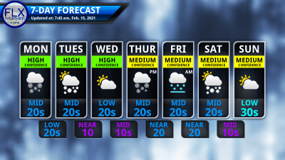 This graphic represents an average over the entire Finger Lakes region. Localized variations should be expected.
 Don’t Miss an Important Update

Lindsey
Hi Drew,
I have to take my son to Henrietta on Wednesday afternoon. How do you think the main roads will be then?
Thanks,
Lindsey
Meteorologist Drew Montreuil
They should be clear and fine by then!
Trish
I have to drive from Candor to Binghamton tomorrow morning 10ish for an appointment. Do you think most issues will be over by then?
Meteorologist Drew Montreuil
The precipitation should be over by then and main roads will be improving. Backroads will probably still be rather messy. Temperatures will be pushing into the low and even mid 30s, especially closer to Binghamton, so that will help, too. I’d plan for some extra travel time, take a look at how things are progressing with road conditions tomorrow morning.
Trish
Thank you!