Latest Weather System
Precipitation is moving into the Finger Lakes from the southwest this morning on schedule.
Temperatures throughout the region are mostly between 31-33 degrees, though a few warmer pockets are into the mid 30s. With many locations right at or around freezing, precipitation type will vary greatly from location to location, even over very short distances.
The two main precipitation types will be freezing rain and non-freezing rain. For areas at or below 32 degrees, the rain will freeze on contact with cold surfaces, resulting in freezing rain. For areas above 32 degrees, the rain will not be able to freeze.
Once a given location makes it above 32 degrees, it should remain above and the ice threat will diminish. Ice that has already fallen may take some time to melt, even as temperatures slowly rise.
Due caution should be exercised this morning, knowing that conditions will be changing with both physical space and time. Overall, the trend will be for temperatures to warm above freezing, gradually reducing the ice threat this morning.
Non-freezing rain will continue through the midday and well into the afternoon hours. During the mid to late afternoon, western areas will see the rain end while eastern areas see some breaks in the rain developing. By the evening, the rain should be east of the area, with only a stray shower lingering behind.
Temperatures will mostly stick to the mid 30s today, though a few upper 30s will be possible. The best chance for upper 30s will be this evening before temperatures fall back to the mid 30s overnight.
A new area of rain showers will move in after midnight and will turn to snow for many areas by Friday morning. This snow will be scattered but may be briefly and locally heavy at times. With temperatures remaining in the mid 30s, reduced visibility will be the primary hazard.
On and off snow will continue throughout Friday, gradually becoming widespread across the northern half of the region, but with generally light to moderate intensity. Again, temperatures will hold steady in the mid 30s, so accumulations will be limited to some grassy surfaces and will not amount to much.
Snow showers will gradually decrease Friday night and early Saturday. With temperatures Friday night in the mid 20s and highs Saturday in the low 30s, some minor accumulations will be possible.

Monitoring Snow Potential Next Week
There is not one, but two weather systems next week that I have been monitoring closely for their potential for impactful winter weather. Here are my latest thoughts.
The first system will move northeast out of the Gulf of Mexico on Saturday, eventually reorganizing along the Mid-Atlantic coast on Sunday. From there, the weather system will track along the New England coast and out to sea.
The current trend on the models has been for the core of snow with this system to stay east of the Finger Lakes, and not really intensify until reaching northern New England.
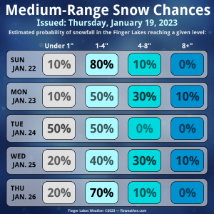
It does seem likely that at least a little snow will fall Sunday night into Monday, either from the system itself, from lake effect in its wake, or a combination of the two.
The chance for a significant snowfall of eight or more inches is around 10%, whereas the chance for snow amounts up to four inches is much higher. Going a bit deeper, the eastern half of the region has a greater chance for snow accumulations than the western half.
Tuesday may have some lingering lake effect snow, but attention will then turn to the second system on Wednesday.
This, too, will be a coastal system. So far, the models have been consistently bringing precipitation into the Finger Lakes. Oftentimes, this includes at least a period of mixed precipitation, which would keep snow totals down.
The chances for moderate to heavy snow look about as high with this second system as with the first, but it is still very early in the process, so a lot can and probably will change.

Be wary of premature forecasts with either of these systems and keep checking back here through the weekend for updates.
More Information:
» Finger Lakes Weather Radar
» Zip Code Forecasts
» Get the FLX Weather Mobile App
Get the latest forecasts delivered to your inbox automatically. This is the best way to ensure you are always seeing the newest information. Subscribing is easy, free, and secure. 
This graphic represents an average over the entire Finger Lakes region. Localized variations should be expected. Stay Updated With Email Alerts


James Hamilton
The New York Times published a good article yesterday on language use in weather forecasts. Check out http://www.nytimes.com/2023/01/18/science/weather-forecasts-language.html when you have the time. Matt Richtel writes really well here about the problems of weather hype terms like “bomb,” “polar vortex,” and “atmospheric river.”