


Increasing Temperatures
High pressure will track eastward from the Mid-Atlantic region to the open waters of the Atlantic Ocean today.
This shift in position will open our region up to warmer and eventually more humid air for a few days. Temperatures will increase first with high temperatures today several degrees warmer than yesterday.
Most areas should be in the mid and upper 80s this afternoon with dewpoints rising into the 60s. A few urbanized areas may flirt with 90 degrees.
The temperature will be held back a degree or two by a deck of thin clouds and some light to moderate levels of wildfire smoke passing through. Air Quality is not expected to be impacted significantly with the smoke mostly staying aloft.
Otherwise, it will be a quiet day. Precipitation is not expected.
A cluster of thunderstorms is expected over Michigan later today. This complex will move eastward overnight, arriving in the Finger Lakes around or after midnight. The complex will be weakening as it moves into the area, so some areas, especially in the east, may not see much rain overnight.
Severe weather is not expected with this complex, either, though some rumbles of thunder will be possible.
A few showers will likely linger into early Thursday morning before a gradual drying and clearing trend.
It will become very humid overnight, with dewpoints and temperatures meeting in the low 70s. For Thursday, dewpoints will remain in the 70s while high temperatures reach the mid 80s.
There is still some uncertainty about how the weather will unfold Thursday afternoon, but the chances for rain appear to be small. The best chance for some showers and storms will be over the eastern half of the region. Anything that does manage to develop could turn strong, so this will be something I will continue to monitor closely.
Mostly clear skies will develop Thursday night, which should allow temperatures to at least slip back into the upper 60s overnight.

Transition This Weekend
Friday will be our best shot at seeing temperatures at or above 90 degrees. Sunshine, a lack of precipitation, and southwest winds will all help the temperature reach its full potential. Dewpoints will hover around 70 degrees, making the heat index several degrees higher.
A cold front will approach from the north late Friday night and Saturday morning. Showers and thunderstorms are likely along the front.
Winds aloft will be strong on Saturday, so even in the morning hours, there could be a chance for some stronger storms. The later in the day the front arrives, the greater the potential for severe weather. A wait-and-see approach is necessary.
Depending on the speed of the front, cooler, less humid air will eventually work its way into the Finger Lakes on Saturday. High temperatures should stick to the mid and upper 70s. The afternoon should end up mostly dry.
Saturday night will be refreshing, with nighttime temperatures dropping into the 50s. Sunday will end up reaching a high in the mid 70s.
There is a small chance for a few showers to pop up during the afternoon hours on Sunday. Most areas will probably not see rain, though. Monday will be similar, with highs in the mid 70s and perhaps a shower or two.
Northwest winds behind the front on Saturday, Sunday, and potentially Monday will all be a bit blustery in the afternoon with gusts over 20 mph.
Temperatures may bump up a couple of degrees on Tuesday. A small chance for a shower will linger. Afternoon highs will continue to moderate toward the middle and end of next week, but should not get much higher than around 80 degrees.
The best chance for rain next week looks to be in the Thursday Night-Friday timeframe.
More Information:
» Finger Lakes Weather Radar
» Zip Code Forecasts
» Get the FLX Weather Mobile App
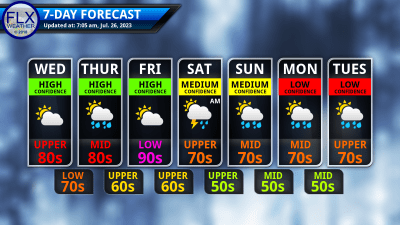
This graphic represents an average over the entire Finger Lakes region. Localized variations should be expected.
FLX Weather Needs Your Support
Finger Lakes Weather relies on monthly donations and business sponsors as its primary sources of funding. Contributions from both of these sources have been declining, even as prices for nearly everything climb.
You can help reverse the negative funding trends by joining the ranks of monthly donors or by sponsoring FLX Weather with your business. Please consider helping out today. Thank you!