Lake Snows
The next two days’ weather will have on and off bouts of lake effect snow with locally moderate accumulations.
Lake snows are increasing this morning as northwest winds establish themselves over the region. A spray of snow exists across the northern parts of the region.
This snow will continue to press south this morning with a second, smaller band of snow during the midday and early afternoon hours.
Locally an inch or two will fall, especially over the favored lake effect areas in the I-90 and I-81 corridors. Travel may be slick at times, especially during any heavier squalls. The transient nature of the bands should prevent greater snow amounts.
Northwest winds will be blustery with gusts around 30 mph. These winds will reduce visibility and cause areas of blowing and drifting snow. Be on the lookout for changing conditions.
Once the second band moves south and dissipates this afternoon, there will be a window for dry conditions during the late afternoon and evening. A few stray flurries will still be possible, but with minimal impacts.
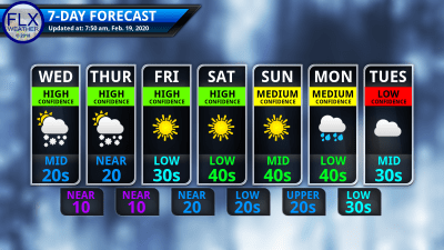
High temperatures this afternoon will be in the mid and upper 20s.
The lake effect process restarts overnight as a more organized and slower moving band develops southeast of Lake Ontario. Wayne, northern Cayuga, and northern Onondaga counties could see localized amounts top six inches overnight and into early Thursday morning.
That snow band will sag south Thursday morning and into the early afternoon, weakening as it does so. Like today, most areas should see an inch or two as it passes through, with even less south of the southern tips of Keuka, Seneca, and Cayuga lakes.
Temperatures on Thursday will start in the single digits and teens and highs will top out within a couple degrees on either side of 20 degrees.
A few more flurries and squalls will develop behind the band Thursday evening and into the overnight. Southwest winds will kick in by Friday morning, taking the lake effect well to the north where it will dissipate.

Weather Quiets Down and Warms Up
A stretch of dry conditions and increasing temperatures will take hold of the region immediately following the lake effect.
Friday will start out clear and cold. Most of the region will be in the single digits with a few areas in the western Southern Tier slipping just below zero. To the northeast, where the lake effect clouds will linger Thursday night, temperatures will start Friday in the teens.
There should scarcely be a cloud in the sky Friday with start-to-finish sunshine. The sun and southwest winds will push temperatures into the upper 20s and low 30s.
Saturday will start with most areas between 15-25 degrees. Sunshine will again be plentiful, and winds will remain from the southwest. Most areas should reach 40 degrees with higher elevations in the upper 30s.
Sunday will be day three of sunshine and southwest winds. Temperatures will start near or above 20 degrees and will top out in the mid and upper 40s.
Clouds will finally return on Monday with some scattered rain showers also moving in. Temperatures should remain mild with highs in the 40s.
Tuesday and Wednesday should remain relatively mild, but probably will be cooler than Sunday. Late next week, colder air will make another brief return before temperatures once again moderate.
Invest Locally!
Looking for new and exciting ways to grow your local business? Consider supporting Finger Lakes Weather with an advertisement and reach thousands of new local leads.
In 2019, Finger Lakes Weather registered over 720,000 page-loads, a 35% increase from 2018’s then record. Continued growth is expected with exciting new offerings coming in 2020.
Rates for tapping into the captive, local audience are extremely competitive and lower than most other local advertising sources. Plus, long-term advertisers, very small businesses, and non-profit organizations enjoy discounts to make advertising even more affordable.
There are no complicated algorithms to crack or confusing behind-the-scenes auctions. The process is simple, too. Just send along your ad image, or have an ad created for you. The ad can then be linked to your website, Facebook page, or wherever you’d like. Images can be changed as often as you like, too.
Advertising on Finger Lakes Weather is a winning proposal for everyone. Your business gets guaranteed local exposure. The Finger Lakes continues to get reliable, accurate weather information. FLX Weather gets the financial support it needs for continued growth.
Fill out the form in the green box for more information! Hurry though, space for new advertisers is limited.

