Small Disturbance Approaches
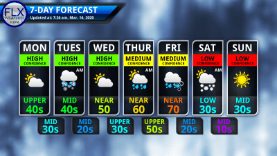
The new week is off to a clear, cold start, but there will be multiple chances for precipitation in the coming days.
Temperatures this morning are in the teens and 20s as high pressure dominates the northeastern United States with clear skies and calm winds. Once the sun is up, temperatures will quickly bounce back with a rapid rise through the 20s and 30s.
High temperatures this afternoon will range from near 50 degrees in the Rochester area to the mid 40s in the higher elevations of the Southern Tier and Central New York. Most areas will be in the upper 40s.
The sunshine will slowly get replaced by clouds today. First, the clouds will be thin and will simply filter some of the sunlight. Through the afternoon, and especially this evening, the clouds will thicken further.
South winds will increase through the day and into the evening as well. Tonight, higher elevations may gust to 30 mph.
Temperatures will fall back into the mid and upper 30s by midnight and remain steady thereafter. The first rain and snow showers should enter the region by midnight. Scattered rain and snow will continue into Tuesday morning before coming to an end.
None of the precipitation should be heavy. Snow is most likely across higher elevations where a dusting on grassy surfaces will be possible. Lower elevations should primarily stay rain.
Winds will turn to the west Tuesday morning behind the disturbance. Temperatures will peak in the low and mid 40s during the early afternoon, then drop several degrees for the late afternoon.
Clouds on Tuesday will remain thick until the evening when skies will begin to clear. A stray snow shower off Lake Ontario will also be possible Tuesday evening, though.

Mid and Late Week Weather
Wednesday’s weather will follow a path similar to today. Morning lows won’t be quite so cold, but will fall down into the 20s. Early sunshine will then be filtered through and eventually replaced by thickening clouds.
South winds on the backside of a small high pressure system and preceding the next low pressure will push temperatures on Wednesday back to around 50 degrees.
Rain will then move in Wednesday night. A few higher elevations of Central New York could see a little snow or even some ice before the precipitation turns to rain by Thursday morning.
Morning showers will then give way to sunshine for Thursday. Winds will start from the northwest, but will turn to the east as yet another system approaches.
A front will begin to form over Upstate New York Thursday afternoon. We should be on the warm side of this with temperatures pushing at least into the 50s. It may end up even warmer, though.
Warm air will continue to stream in Thursday night, counteracting any nighttime cooling. Temperatures Friday morning may still be well into the 50s. These warm temperatures will be accompanied by a batch of overnight rain and gusty southwest winds
How warm Friday gets will be determined by how quickly a cold front moves through. It seems likely that it will be a very warm day with 60s or even low 70s possible.
If the front is timed right and passes through late in the day or in the evening, showers and some thunderstorms will be possible Friday afternoon.
This cold front will be very strong with a substantial drop in temperature expected. Lows Saturday should be down in the 20s with highs in the afternoon only in the low 30s. A few morning snow showers will be possible, along with gusty northwest winds.
This coming Sunday looks very similar to yesterday, with sunny skies, but cool temperatures in the mid 30s.
Quick Note on COVID-19
Over the last week or so, our sense of normalcy and security has been shaken. Personally, I got a taste of what it is like to not know what is hype and what is factual. The uncertainty of what information to use, and how to react to it, has only strengthened my resolve to provide a factual, no-hype weather service. At least for weather events, I want people to know they can always rely on Finger Lakes Weather for calm, scientific analysis.
With so much disruption around us, I am hoping that Finger Lakes Weather can provide you with a sense of routine and normalcy. I have no plans to alter my daily update routine or change my services. Outside of this simple notice, my focus will remain on the weather.
I do urge everyone to look after one another. Be kind. Be compassionate. Be helpful. Find your niche in making your community stronger.
Please continue to support local businesses. Many are being severely impacted by the economic fall-out of the mass cancellations. Gift cards are a tremendous way to support local businesses now while maintaining social distancing.
My prayers are joined with millions of others for the sick and suffering and for a swift end to the pandemic.


Jane
Thanks very much for your thoughtful caring message. I really appreciate the service and care that you give.
Yes, we are all in this together.
Shirley
I am today making a small donation to your cause! I wanted you to know that it is primarily because of your last three sentences of today’s weather report. It is rare to have such a personal blessing issued. We all need to be blessing and helping each other. Thank you for the reminder!!!! (And the prayers)
Meteorologist Drew Montreuil
Thank you, Shirley. You are very generous and I appreciate the financial support, especially since some of my donors who have been impacted more severely have had to cancel their donations for the meantime.