Active through Wednesday
With a strong jet stream overhead, our weather will be busy over the next 36 hours with three or four chances for rain and storms.
The first chance is early this morning. Scattered showers are falling throughout the region as a disturbance dives southeast. None of the rain is overly heavy, and no thunderstorms exist.
These showers will quickly move on by the mid to late morning hours. A few breaks of sun may work their way through the clouds this afternoon, but mostly it will just be cloudy.
Southwest winds will still lead to an increase in the temperature, despite the clouds. Highs will range from the low 70s along I-90 to the mid 60s in the higher elevations of Central New York. Most areas should be at or above 70, and Rochester could sneak into the mid 70s.
The next disturbance will eject out of the northern Great Lakes this evening. Showers and thunderstorms will pop up, with the best chances for thunderstorms coming over the western half of the region between 10 PM and 2 AM.
These thunderstorms will feed off a layer of warm air aloft. Since this warm air is not at the surface, thunderstorm winds will be prevented from reaching the surface in most cases. The biggest threat from these storms, therefore, will be frequent lightning and heavy downpours.
Temperatures tonight will stay in the low 60s for all but areas southeast of an Elmira-Ithaca-Cortland line, where upper 50s are more likely.
The third chance for rain is the least certain, coming early Wednesday morning. A few more scattered showers and storms will be possible as activity develops this evening over Minnesota and travels east through the overnight.
Lastly, and also fairly uncertain, will be showers and thunderstorms early Wednesday afternoon. Most areas should see some rain, but thunderstorms are most possible over the southern half of the region.
Severe weather from either period of thunderstorms seems unlikely, but Wednesday afternoon will need to be monitored, just in case.
Highs on Wednesday will range through the 70s, with lower elevations generally warmer than higher elevations.

End of Week and Weekend Weather
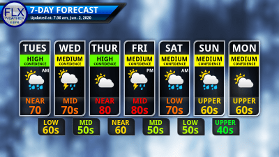
The jet stream will lift north slightly for Thursday and Friday, allowing warmer and quieter weather to build into the region.
Thursday will start out sunny with morning low temperatures in the mid 50s. The sunshine will quickly warm the atmosphere, leading to some fair-weather clouds developing by mid-morning.
These clouds will remain through the afternoon, but there will still be plenty of sunshine, and no precipitation is expected. Afternoon highs will be in the upper 70s and low 80s.
Friday will start off similarly, with sunshine and mild morning temperatures. Lows will start out around 60 before afternoon highs reach into the low and mid 80s.
This time, there will be a small chance for a stray afternoon shower or storm.
The chances for rain will increase Friday night as a cold front marches through. Behind this front, the weekend will turn slightly cooler. Highs Saturday should still manage the low 70s with mid and upper 60s more likely for Sunday and Monday.
A few stray showers may linger Saturday morning, and a few more may pop up Sunday afternoon. Monday looks dry, but the rest of next week is too uncertain to draw many conclusions about.


Michael Nash
Thanks, Drew. Your email messages are top notch and I’m glad to see you getting more and more support. I count on your forecasts because they are honest and you stand behind your work.
Meteorologist Drew Montreuil
Thanks, Michael!