Feast or Famine Rainfall
The high pressure system that was parked overhead much of the week is finally well to our southeast off the coast of the Mid-Atlantic.
Spinning behind the high is an area of low pressure in the upper atmosphere that has meandered northward from the Carolinas. This low has helped increase our moisture and led to a surprising amount of thunderstorm activity yesterday.
Now that this low is here to influence our weather, it will stick around for a few days, bringing us a new normal of warm, slightly muggy weather with scattered afternoon thunderstorms.
Like yesterday, the models this morning are not bullish on the thunderstorm development, but I would suspect that they are likely underdoing the chances once again.
Thunderstorms will start to develop after 3 PM and will gradually form a couple of clusters for the late afternoon and early evening hours. Once the sun sets, the storms will quickly dissipate.
Rain amounts will vary greatly, with some areas seeing no rain while neighboring towns see heavy downpours. Yesterday, a few isolated locations saw over an inch while a couple miles away, next to nothing fell.
Thunderstorms will also have frequent lightning and a few wind gusts, but severe storms should be very few and far between, if any develop at all.
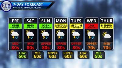
Temperatures today will not be quite as hot as yesterday thanks to an increase in clouds and a broader area at risk for thunderstorms. Highs will still be in the low and mid 80s, though.
Saturday should be very similar, except that the chances for storms look greater. Sunday’s rain chances, however, look smaller. That will allow temperatures to gain a couple degrees back, pushing some areas close to 90 degrees.

Next Week’s Weather
The daily chances for rain and thunderstorms will continue Monday, Tuesday, and possibly into Wednesday.
Rain and thunder may be more widespread on these days as a series of weak systems move through the region.
The best chance for strong thunderstorms, if there are any, looks to be on Tuesday.
Ultimately, how these days unfold will depend on the timing and strength of these impulses. That remains too uncertain this far out to be sure of.
Temperatures will be influenced some by the precipitation chances but should generally stay warm and muggy with highs well into the 80s.
The second half of the week looks drier as the heat backs off a little bit. Temperatures Thursday and Friday should be in the 70s.
A warming trend is expected to quickly take hold after that, with hot weather possible for the end of June and first part of July.
Stay Updated With Email Alerts
Get the latest forecasts delivered to your inbox automatically. This is the best way to ensure you are always seeing the newest information. Subscribing is easy, free, and secure.


