Early Week Sunshine
A dominating high pressure system is centered just off the coast of New England this morning.
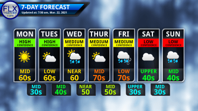
The result will be a near duplication of yesterday’s weather before the weather gradually turns more active.
Nothing more than a few thin cirrus clouds are expected today. These will not interrupt the start-to-finish sunshine at all today.
South winds will blow at 5-10 mph, but the airmass to our south is very uniform. So, despite the south winds, temperatures today will be similar to yesterday. Look for highs in the low and mid 60s once again.
Temperatures tonight will range through the 30s. A few more thin clouds will work in, especially after midnight.
Sunshine tomorrow will be filtered by a further increase in thin clouds. The clouds will be widespread by the midday and afternoon hours, but they should not completely block the sunshine.
Still, without the full impact of the sun, temperatures Tuesday may end up a degree or two shy of today’s highs.

Active Late Week
Clouds will thicken further Tuesday night and a few rain showers will move into the region before the sun rises on Wednesday. Morning clouds and showers will be common, but some afternoon sun may work out, especially to the northwest.
Southeast winds will blow at 10-15 mph. Temperatures are complex due to the wind and cloud cover. While the Rochester area could go above 66 degrees, highs may stick to the mid or even low 50s across the southern and especially southeastern Finger Lakes.
Skies will eventually clear out Wednesday night, leading to morning sun on Thursday. Southwest winds will take over, and despite another increase in thin clouds, temperatures will likely reach their peak for the week.
All areas should at least reach 70 degrees, and many areas should push into the mid 70s.
A strong low pressure system will move into the area on Friday. Currently, the track places the low pressure center near Buffalo on Friday afternoon. While the track will likely need adjusting, as long as the primary path is to our west, a period of high winds will be possible.
Rain will be likely on Friday as well, possibly with a few rumbles of thunder. A more organized thunderstorm event looks unlikely at this time, but the possibility will be monitored given all the wind energy in the atmosphere.
Temperatures Friday are highly uncertain at this time, but chances are good for more 60s or 70s.
Behind this system, temperatures will retreat back into the 50s for the weekend and 40s for early next week. A steady dose of temperatures in the 45-55 degree range will follow, with daily fluctuations.
No significant late season cold spells are showing on the models at this time, but that does not necessarily mean we are completely done with snow. However, we are at the point of the year where any snow that falls will melt quickly thereafter.
More Information:
» Finger Lakes Weather Radar
» Zip Code Forecasts
Get the latest forecasts delivered to your inbox automatically. This is the best way to ensure you are always seeing the newest information. Subscribing is easy, free, and secure.

This graphic represents an average over the entire Finger Lakes region. Localized variations should be expected.
Stay Updated With Email Alerts


