


Cool Through Wednesday
A large low pressure system is spinning over eastern Canada, delivering cool air into the Finger Lakes region.
There are a few showers dotting the radar this morning, but most areas are relatively dry to start today. This trend will continue to hold through the morning and first half of the afternoon.
An impulse of energy rotating around the low will arrive in the later afternoon hours, leading to an uptick in showers. This will continue into the early evening hours, with some of the rain turning over to snow showers.
Southwest winds will blow steadily today with speeds of 10-15 mph. As usual with southwest winds, the strongest wind speeds will be in the far western Finger Lakes. Top gusts on the day should be around 25 mph for most of the Finger Lakes.
Temperatures will be below seasonal averages today with highs mostly in the mid 40s. After sunset, temperatures will be quick to fall into the 30s, with many places getting to or below freezing overnight. A few cold pockets may slip into the 20s, but this should be uncommon.
Overnight flurries will gradually taper off and move out of the region. A light coating of snow on grassy surfaces, cars, and other cold surfaces will be possible in some areas. A stray flurry may linger into the morning hours Wednesday downwind of Lake Ontario in the northeastern Finger Lakes.
Much of Wednesday will be cloudy but dry. Some sun should eventually work its way out late in the day. Winds will be from the northwest at around 10 mph.
High temperatures will range from the mid 40s in some higher elevations and southeast of Lake Ontario, to the mid 50s through the Southern Tier.
Temperatures Wednesday night will fall back into the 30s once again. Mid 30s will be common, but a few pockets of low 30s will also be possible. A warm front will move into the area during the predawn hours, possibly leading to a slight rise in temperatures and a few stray showers.

Quick Warm-Up
Sunshine should become plentiful on Thursday, though there will still be some occasional clouds drifting through.
A slight southerly breeze will set up behind the morning warn front, though there are some questions regarding how far north the front will travel.
This should set up a gradient in temperatures, with mid 70s in the southwestern parts of the region down to mid or even low 60s in the northeastern parts. Most areas will probably end up in the upper 60s or low 70s.
The front will lift further north Thursday night. South winds will hold nighttime temperatures in the low 50s.
Friday will be the warmest day of the week with the area solidly in the warm sector of the next weather system. Southwest winds, sunshine, and a warm start will propel highs to the upper 70s and low 80s.
Dewpoints on Friday look low enough to prevent much in the way of shower activity from developing. Instead, relative humidity values may drop below 30 percent for a time, leading to an increase in brush fire risk.
Saturday is a bit less certain as a cold front starts to move eastward through the Great Lakes, but has its progress halted as low pressure rides along the front and is deflected westward by high pressure over New England.
This may lead to a cloudy day but with little rain until the nighttime hours. It will become blustery as these two opposite weather systems bump up against one another. Southeast winds could approach 20 mph with gusts over 40 mph.
Temperatures will remain warm until the front moves through with highs well into the 70s likely. Eventually, the front will arrive with the potential for some slow moving, heavier rain. Exact rainfall amounts are uncertain at this time, with a high degree of variability showing on the models.
Steady rain may linger into very early Sunday before transitioning to more on and off showers. Sunday should not be as windy as Saturday.
Another pool of cool air will move into the region behind the rain, with highs Sunday in the low 50s and mid 40s on Monday. Temperatures should moderate back to the 50s by the middle of next week, but are not very likely to get much warmer than that for some time.
More Information:
» Finger Lakes Weather Radar
» Zip Code Forecasts
» Get the FLX Weather Mobile App
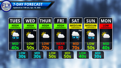
This graphic represents an average over the entire Finger Lakes region. Localized variations should be expected.
