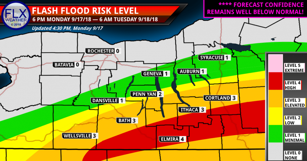
High Flash Flood Risk
Up-to-the-second NO HYPE weather updates for the Finger Lakes and Southern Tier region. Flash flooding is likely tonight as the remains of Hurricane Florence interact with a frontal boundary.
Here is a summary of the changes since my post this morning, which can be found further down the page. An updated flash flood map can also be found further down the page.
- Small increase in confidence that heaviest rain will extend across the Southern Tier, likely just south of Ithaca and Cortland and north of Binghamton. Elmira is in the bulls-eye should this come to be.
- Extension of northern edge of minimal and low flood risks due to alternate scenarios that are unlikely, but still possible.
Important Notes
- Forecast confidence remains VERY LOW. After the morning models started to show some consistency, the afternoon models went crazy with an even wider spread in possibilities.
- I’ve hung my hat, so to speak, on the morning consensus.
- Destructive flash flooding will be possible on a small, localized scale.
- Widepsread minor flooding is possible across the Southern Tier and Southern FLX.
- Flooding is unlikely further north.
- Rain amounts will generally be 1-3 inches in the orange and red shaded areas, but with localized amounts over 4 inches.
I will NOT be doing live video tonight. I have a cold and do not think I could manage. Live blogging will be much easier.
↓ SCROLL DOWN FOR LIVE BLOG FEED ↓
Support Finger Lakes Weather
Finger Lakes Weather needs your support to continue providing live updates during extreme weather! Please consider a monthly or one-time donation to help Finger Lakes Weather. Thank you for supporting Finger Lakes Weather!
Monthly Donation
Single Donation
Live Weather Blog
Up to the second local weather updates for the Finger Lakes, Western New York, and Central New York. This feed should update automatically but may need an occasional refresh. Join the conversation in the chat box in the lower right corner.
Live Finger Lakes Radar
Click here for a larger version of Finger Lakes Weather’s live, interactive, mobile-friendly radar.
Flooding Threats

Morning Blog Post
Get a more in-depth look at the day’s forecast from this morning’s blog post:
Weather Planner: Friday, April 3, 2026
Friday will be much warmer than Thursday with highs getting to around 70 degrees. The best chance for a few scattered showers and light thunderstorms will come during the late afternoon and early evening hours. Temperatures will briefly drop overnight as north winds temporarily take over before turning back to the south early Saturday.… Read More


John Gregoire
1.13 started at 1730 and ended at 0530 here near Mecklenburg.
Sara
Is there a way for me to track how much rain has actually fallen? I have rental properties and want to know when I need to worry.
Meteorologist Drew Montreuil
There is not much in the way of live data…most of it is after the fact. There are radar estimates that you can possibly find, but they aren’t the most accurate.
Gail Dalmat
Thank you, Drew! Get some good sleep tonight, okay? It’s going around–a friend in the Southeastern US also has a bad cold.
Bill Calhoun
Accuweather and Weather Underground have just barely an inch for this storm for Lansing, NY. You have us around 3″. Who to believe….. 🙂
Meteorologist Drew Montreuil
You very well could end up under an inch.
Accuweather, and probably Weather Underground, generate their forecasts straight from model data…usually the inferior GFS model. The GFS does not have nearly as high rain totals as other, more reliable models…and it has its axis of heaviest rain further north.