


Wind, Cold, and Snow
A strong coastal low is situated just northeast of Maine this morning, while a sprawling high has spread across the southeastern quadrant of the nation.
The low will have the primary influence on our weather today, though the high will have its role as well.
Namely, as these two large pressure systems bump up on one another, strong winds will develop this morning and persist into the afternoon.
These winds will be from the west and northwest and will gust over 40 mph at times. The best chance for gusts of 45 mph or greater will be over higher elevations and along the shore of Lake Ontario east of Rochester.
Moisture on the backside of the low led to areas of lake effect snow overnight. Numerous areas of flurries and squalls still exist in the area as of 7 AM. These should diminish through the morning as the atmosphere warms and the winds increase.
Still, a few slick roads are likely this morning, so use due caution as necessary.
Areas that have snow on the ground this morning will lose it this afternoon as high push into the upper 30s and low 40s. A few stray snow showers may continue into the afternoon, but with no accumulation. Skies will remain thick with clouds, but a few glimpses of the sun will be possible from time to time.
Skies will clear tonight, and if not for the incoming high pressure, temperatures would have probably fallen sharply. However, west winds will persist tonight, though not as strong as they are during the day. Gusts overnight will be closer to or a bit above 20 mph.
The wind will help keep temperatures up, but many areas will still end up near or slightly below freezing. As usual, the Southern Tier will be coldest, with lows in the upper and locally mid 20s.

Milder Weather Ahead
Tomorrow, the high pressure will be moving off the coast of the Carolinas, which is a prime location for mild weather in the Finger Lakes.
Winds will remain from the west and may even become a bit northwesterly, but the upstream source of the incoming air will be from the Mississippi Valley. The wind will still be a bit blustery, with gusts around 30 mph.
The wind will team up with bright, sun-filled skies to push temperatures well into the 50s. A few areas could break into the upper 50s, but most will see mid 50s.
The wind will become more southerly on Saturday, pushing temperatures even higher. Most areas should be at or above 60 degrees.
Saturday will start out with sunshine, but clouds will increase through the day. Much of the afternoon will turn out cloudy as the next weather system approaches.
That system will bring rain into the area Saturday night and into the first half of Sunday. A few showers may linger into Sunday afternoon. Highs will settle in the mid 50s.
Sunshine will return on Monday with some blustery northwest winds. Highs will make a brief retreat to around 50 degrees.
A rapid warm up is then expected for the middle of next week. With persistent south winds and partly cloudy skies, highs on Tuesday will be near 70 degrees while Wednesday may push towards 80 degrees. Thursday should also be at least into the 70s, but is less certain as a cold front will be approaching.
This front will not be too powerful though, with plenty of warm weather expected as we head into May.
More Information:
» Finger Lakes Weather Radar
» Zip Code Forecasts
Want to support Finger Lakes Weather and keep the no-hype, local information flowing? Please consider a monthly donation using the form below, or place an ad for your business on Finger Lakes Weather. Thank you for your continued support of Local Weather!
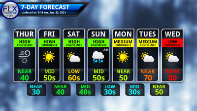
This graphic represents an average over the entire Finger Lakes region. Localized variations should be expected. Support FLX Weather