


Temperatures on the Rise
High pressure will develop over the area today and strengthen as it centers itself just off the Mid-Atlantic coast this weekend.
Combined with the eventual approach of a cold front late Sunday, these two features will pump heat and some humidity northward into the Finger Lakes.
Today will not be too hot as the weather pattern just starts to take shape. It will be a quiet, sunny day, though.
There are some areas of fog across the Southern Tier to start, but that should burn off within a couple of hours. Otherwise, there will be plenty of sunshine and just a few small fair weather clouds this afternoon. A light northwest breeze will blow at speeds around 5 mph.
Temperatures will rise into the low 80s this afternoon. A few hilltops may end up just shy of 80 degrees. Dewpoints will be low and comfortable in the mid 50s, yielding relative humidity values of 35-45 percent this afternoon.
Skies will be clear through the night with nearly calm winds. Overnight lows will range from the mid 50s to the low 60s and some areas of fog may once again develop across the Southern Tier.
Saturday will be another quiet day. There will be plenty of sunshine, though there should be a few more clouds in the afternoon compared to today. Winds will be almost non-existent.
Temperatures will warm quickly and most areas should be above 85 degrees in the afternoon. A few areas could hit 90, especially in and around Rochester. Dewpoints, however, will remain in the upper 50s.
Southerly winds will develop Saturday night, pushing dewpoints into the 60s and keeping temperatures elevated. A gradual increase in thin clouds will also help make for a warm night. Overnight lows will be between 65-70 degrees, with the warmest temperatures across the northern half of the region, as usual.
That will get temperatures off to a running start Sunday. South winds will turn to the southwest and increase to around 10 mph. Even with clouds filtering the sunshine, most areas should get near or above 90 degrees. Some northern areas could push towards 95 degrees.
Dewpoints will be in the 60s during the morning but may retreat to the 50s for a time in the afternoon. This should keep the heat index in check, but caution against the heat will still be prudent.

Heat Ends, then Returns
Sunday will be a dry day until late as the cold front approaches. A few showers and storms may make it into the western half of the Finger Lakes before sunset.
The greater chance for rain will come Sunday night, and possibly mostly near and after midnight. Showers and thunderstorms will be likely.
Most areas should see at least a little rain, though some pockets will probably end up getting missed. Localized pockets may see over a half-inch, but the storms will be progressive, so high rain amounts of an inch or more seem unlikely.
Severe weather is also not expected, with weak winds aloft, marginal dewpoints, and cooler nighttime air in place.
This front will reset the temperature, for a couple days at least. Monday will have highs in the low and mid 70s, while Tuesday will be a degree or two cooler. Both days should have plenty of sunshine and no rainfall.
Dry weather is expected to remain into Wednesday and Thursday as well with temperatures on the rise. Wednesday will be similar to today with low 80s, while Thursday will be similar to Saturday with upper 80s. Friday will follow the pattern and may match Sunday with temperatures into the 90s.
The next substantial chances for rain after Sunday night will not come until next weekend, but time will tell how helpful it will be to the overall rainfall deficits most areas are experiencing at this point.
More Information:
» Finger Lakes Weather Radar
» Zip Code Forecasts
» Get the FLX Weather Mobile App
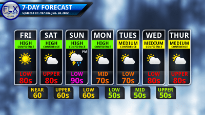
This graphic represents an average over the entire Finger Lakes region. Localized variations should be expected.
Get the FLX Weather App!
Take FLX Weather with you so you always have the latest weather information!
When you download, be sure to enable location services. The app will automatically display the forecast for your location. Plus, you can save several locations for quick and easy forecasts for around the region.
Other features on the app include an improved 7-day outlook, the latest blog post, radar, alerts, and a Live Updates feature.
The app is FREE on both Apple and Android, thanks to the generous financial support of my donors and sponsors. Search “Finger Lakes Weather”, or use the links here:
![]()
![]()