


Friday-Saturday Weather
A couple of weak impulses of energy in the atmosphere will swing through the area over the next couple of days.
These will interact with increasing heat and some humidity to produce a few stray afternoon showers and storms both Friday and Saturday.
Subtle disturbances like these can be difficult for the models to resolve, so there is always a question of how much to trust them. I have seen similar situations both fizzle to nothing and exceed expectations in the past.
The area most favored for some afternoon showers and storms today will be across the Southern Tier and into the eastern half of the Finger Lakes. These areas are not exclusive to the rest of the region, however, so anyone could see a bit of rain. Chances are, though, that most areas will not see rain, and that those that do will not see much benefit from it.
Tomorrow will be a similar situation, though the uncertainty of showers and storms developing is even higher. Most, if not all, day will be dry. Both days are looking at the time period after 3 PM as the most likely time for rain.
As is often the case in these types of situations, widespread severe weather is not expected, but individual storm cells may have brief periods where they become strong enough for some localized wind damage or small hail.
Temperatures will remain warm and will be on the rise. Highs today will be similar to yesterday, with mid and a few upper 80s. Saturday will be warmer, with upper 80s and low 90s. Dewpoints both Friday and Saturday will be in the upper 50s through the early afternoon, but then rising to the low and mid 60s late this afternoon.
Winds will be from the southwest, though they may turn more westerly for a time this afternoon. Wind speeds today will be 5-10 mph while Saturday will be closer to 10 mph.

Hot, Stormy Sunday-Sunday Night
A much better organized weather system will push a cold front into the area late Sunday.
A few showers and storms will be possible as early as Sunday morning as leftover activity from the night before over the Midwest moves into the area.
This should clear out before midday, leaving sunshine and blustery southwest winds in place. Gusts as high as 30-35 mph will be possible. Temperatures should race into the low and mid 90s with dewpoints in the low 60s.
The chance for afternoon storms remains a major question, but the chances for rain will increase Sunday night. Rain and nighttime thunderstorms are likely, though precipitation amounts will not be evenly distributed.
Showers will linger into early Monday as the front moves through. Monday afternoon should see increasing sun and some blustery northwest winds. Highs will reach the low 80s. Tuesday will pick up where Monday leaves off with sunshine, low humidity, and comfortable highs in the upper 70s and low 80s.
Temperatures should get a mid-week boost as southerly flow returns ahead of the next weather maker. That should bring some showers and thunderstorms in for Thursday and Thursday night. Again, though, the precipitation looks hit-or-miss with highly variable rainfall amounts.
More Information:
» Finger Lakes Weather Radar
» Zip Code Forecasts
» Get the FLX Weather Mobile App
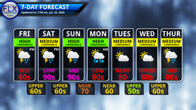
This graphic represents an average over the entire Finger Lakes region. Localized variations should be expected.
Get the FLX Weather App!
Take FLX Weather with you so you always have the latest weather information!
When you download, be sure to enable location services. The app will automatically display the forecast for your location. Plus, you can save several locations for quick and easy forecasts for around the region.
Other features on the app include an improved 7-day outlook, the latest blog post, radar, alerts, and a Live Updates feature.
The app is FREE on both Apple and Android, thanks to the generous financial support of my donors and sponsors. Search “Finger Lakes Weather”, or use the links here:
![]()
![]()