![While the fine details will vary from place to place and hour to hour, messy travel conditions from snow and ice and can counted on this afternoon and evening. [Photo by Gwen Moshier]](https://i0.wp.com/flxweather.com/wp-content/uploads/2023/02/2023-02-22-finger-lakes-weather-forecast-snow-ice-freezing-rain-sleet.jpg?resize=1200%2C630&ssl=1)
Overall Messages Among Variable Details
Much of the nation will be impacted in some way by a large and powerful storm that is ejecting out of the Rockies this morning and will track into the Great Lakes region.
A strong high pressure system is also in place across central Canada, helping to lock cold air in across the northern tier of the United States.
Here in the Finger Lakes, we will be right in the battleground between cold and warm air, resulting in snowy and icy precipitation.
The precipitation will spread from southwest to northeast during the midday and early afternoon hours. With cold air firmly entrenched throughout the different levels of the atmosphere, this precipitation will likely start as snow.
Some of the snow may come down heavy for a time, with snowfall rates locally up to an inch per hour for brief periods. Warm air aloft will come racing in, though, and by the mid-afternoon, precipitation types across the region will begin to vary.
Snow, sleet, and freezing rain will be ongoing throughout the area into the evening hours, when precipitation should begin to taper off and change to non-freezing rain. The variation in precipitation types will be large, with areas within a couple miles of each other possibly seeing different precipitation types.
Expect a general 1-3 inches of snow, with locally more across the northern third of the region. Up to an inch of sleet, and anywhere from a glaze to two-tenths of an inch of ice are also expected. Higher elevations will have the highest chance of larger amounts of ice.
The bottom line is that travel everywhere will be slippery and difficult this afternoon and evening, no matter what precipitation types are falling. There will be periods of heavy precipitation, but overall, the mixing of precipitation types should prevent too much of any one type from accumulating.
The condition of individual roads will vary based on the precipitation type, intensity, elevation, and road treatment plans. It is nearly impossible to nail down these specifics, especially since they are partially dependent on how humans react to the weather. If you are debating whether to travel, it is probably safer to assume roads will be bad and stay home. If staying home is not an option, plan for plenty of extra time and take it slow. Some sporadic power outages may also be possible.
Conditions will improve after midnight from south to north as temperatures nose their way above freezing. Some lingering precipitation may still be in the area early Thursday morning, with some areas of ice still possible.
A sharp gradient in temperature will develop during the day Thursday, ranging from the upper 20s along the shore of Lake Ontario all the way to the low 50s near the NY-PA state line. Most of the region should be above freezing with some areas of drizzle. Sunshine may work out in the Southern Tier during the afternoon.
Wind speeds throughout Wednesday and Thursday will be light. Some occasional winds may reach 10 mph with gusts to 20 mph, but much of the time, the winds will be lighter. A general east wind will blow today before tomorrow’s winds become variable.

Active, Wintry Weather Remains
Thursday evening, a cold front will drop southeast across the region. Scattered showers, perhaps with a rumble of thunder and some graupel, are likely with the front.
Winds will turn to the west, then northwest behind the front and increase. By Friday morning, gusts of 30-40 mph will be common with temperatures falling through the 20s.
A spray of lake effect flurries and a few squalls will be likely Friday morning but should taper off for the afternoon. Locally an inch or two may fall, but most areas will just see a coating of snow.
The winds will also gradually diminish during the afternoon, but temperatures will probably only continue to creep downward throughout the day. Afternoon temperatures should be in the low 20s, and nighttime temperatures will be into the 10s.
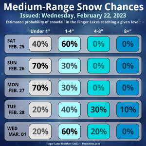
There will be a couple of weak systems passing by this weekend. Right now, Saturday looks favorable for some light snow, while Sunday may see its system pass to our north. This could bring some sun and highs up around 40 degrees.
Another powerful weather system will move in for Monday and Tuesday next week, with lingering effects possible into Wednesday.
Precipitation is highly likely on Monday, but whether enough warm air moves in to keep this as mainly rain, or if cold air stays entrenched and sets up another ice event, is uncertain.

Another uncertainty is how Tuesday unfolds. A secondary low may develop along the coast, resulting in a belt of snow between the new and old low pressure systems. There is at least a small chance for significant snow from this, though currently, a lighter snow is much more likely.
Wind may also become a concern with this system, but that depends on the exact track and strength of the first low pressure system.
By Wednesday, the impacts will mostly be wind and lingering lake effect.
Another weather system looks possible late next week, but is too far out for any real speculation on what it may bring. Some quieter weather may move in behind that.
More Information:
» Finger Lakes Weather Radar
» Zip Code Forecasts
» Get the FLX Weather Mobile App
Get the latest forecasts delivered to your inbox automatically. This is the best way to ensure you are always seeing the newest information. Subscribing is easy, free, and secure. 
This graphic represents an average over the entire Finger Lakes region. Localized variations should be expected.
Stay Updated With Email Alerts


