


High Pressure
A large area of high pressure has built into the Finger Lakes and will bring a couple days of quiet weather before things turn more active once again.
The high is centered over the Upper Great Lakes this morning. With a clockwise flow of air around the high, that means another day of northwest winds keeping temperatures down.
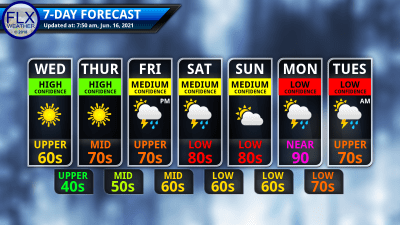
Despite start-to-finish expanses of bright, blue skies, it will be on the cool side today. Highs will range from the low and mid 60s in higher elevations to the upper 60s in lower elevations.
The wind will not be as strong as yesterday, but still breezy, with the occasional gust reaching 25 mph.
Clear skies will persist overnight and winds will drop as the high moves closer. Temperatures will quickly fall this evening and should end up in the 40s throughout the region. Typically colder areas in the Southern Tier could slip all the way to the low 40s by Thursday morning.
Thursday will be another sunny day, though a few more thin wispy cirrus clouds will make their way into the area.
At the surface, winds will remain from the northwest with speeds around 5 mph. Aloft, the wind will start to turn to the west and southwest, allowing warmer air to move back into the region. This should result in a pleasant day with highs in the low and mid 70s.
Thursday night will start out mostly clear, but some clouds will start to move in after midnight. Temperatures will not be as cool, but will still be comfortable, with Friday morning lows in the 50s.

Thunderstorm Chances
A pair of weather systems will bring chances for thunderstorms, first late Friday into Saturday, and then again Monday into early Tuesday.
Most of Friday will be dry with sunshine filtering through thin clouds. Temperatures will add a few more degrees, and a couple places could sneak to 80 degrees.
Late in the afternoon, scattered showers and thunderstorms will move in from the west. The atmosphere will remain favorable for thunderstorms even after sunset and into Saturday.
The best chance for widespread thunderstorms seems to be focusing on Saturday morning. The more trustworthy weather models have been rather consistent in this timing, but it remains uncertain. Even a couple hours difference could have significant impacts on the weather we experience.
Even with a focus on the morning hours, the thunderstorms could be robust with frequent lightning and perhaps some wind and hail threats. Uncertainties in the details abound, but at this point, it seems likely that there will be thunderstorms in the area at least late Friday and early Saturday.
Sunday will be a quiet day between systems with a mix of sun and clouds and highs reaching the low 80s.
Warm and humid air will rush into the region on Monday. Highs could push toward or above 90 degrees, but that will partially depend on the next round of thunderstorm potential.
Once again, the early indications are that the timing of the best chance for widespread thunderstorms will be during the overnight or morning hours as we head into Tuesday. That may prevent a more considerable severe threat. However, the uncertainties for early next week are substantially higher than even Saturday’s event.
Whenever the cold front that will trigger these storms moves through, the middle and end of next week looks quiet. Temperatures will be coolest on Wednesday again next week, with highs probably reaching the low 70s. Another warming trend will take hold from there.
More Information:
» Finger Lakes Weather Radar
» Zip Code Forecasts
This graphic represents an average over the entire Finger Lakes region. Localized variations should be expected.
Get the New FLX Weather App!
I am super excited to finally be able to bring you a dedicated mobile app for Finger Lakes Weather! This project has been in the works for years and has been made possible by your support and generosity.
When you download, be sure to enable location services. The app will automatically display the forecast for your location. Plus, you can save several locations for quick and easy forecasts for around the region.
Other features on the app include an improved 7-day outlook, the latest blog post, radar, alerts, and a Live Updates feature.
The app is FREE on both Apple and Android, thanks to the generous financial support of my donors and sponsors. Search “Finger Lakes Weather”, or use the links here:
![]()
![]()
Please be sure to rate and review, and help spread the word! Thank you!