


Christmas Weekend Weather
After a couple of rounds of snow the last two days, our weather pattern will warm up for Friday and Saturday.
While most of the Finger Lakes are starting out in the 20s this morning, mid 30s are making their way northward into Western New York. Warmer air will not take long to infiltrate our region this morning, especially over the western half of our area.
Temperatures will make it into the mid 40s for most of the region this afternoon. Some areas that have a decent snow cover this morning may only reach the low 40s and a few locations may see their snow cover survive the day.
Skies will be mostly cloudy throughout the day, but no precipitation is expected until after sunset. Some drizzle will move in early this evening followed by rain showers through the overnight. Any areas that still have snow early this evening may also see some fog.
Nighttime temperatures will initially drop to the mid and upper 30s but will rise back to near 40 overnight. Mid 40s are likely for highs again tomorrow on Christmas day.
Widespread rain will develop over the region on Christmas morning and continue on and off throughout the day. Rainfall amounts by the time it tapers off in the evening will be around or over a half inch. Flash flooding is not expected, but poor drainage areas that have been wet seemingly since the early summer will likely see more ponding.
Temperatures will hold on to the low 40s into the early evening but will gradually retreat to the low 30s by Sunday morning. Some lake effect snow may flare up southeast of Lake Ontario in the same general areas that saw the lake effect snow Wednesday night and early Thursday. With temperatures mostly above freezing, travel conditions should remain in decent shape, though localized variations will be likely.
Northwest winds will be a bit blustery on Sunday, helping hold temperatures to the mid 30s. Top wind gusts should stay under 30 mph, though.

Unsettled Next Week
An active weather pattern will remain in place across the northern tier of the country throughout next week. While some intense cold invades the Northern Plains, our temperatures will remain near or above average through the end of 2021.
On Monday, a weather system will be nearby but mostly south of the region. A few snow showers will spread into the area, but with little impact.
Uncertainty remains in the storm track, and a more northern push, which the models had been indicating, would introduce a snow to rain scenario, possibly with a little ice during the transition. I will make a point to post an update on Sunday if this scenario begins to look more likely again.
Tuesday looks to be a quieter day, though a stray rain shower or flurry cannot be ruled out. Otherwise, clouds are likely to be thick.
Winds will be back to the south, helping nudge temperatures back into the low 40s. Rain showers will be possible on Wednesday with temperatures remaining in the 40s.
Behind that system, temperatures will settle into the 30s into next weekend. There are some indications that some colder air may be possible in early January, but time will tell.
Forecast confidence throughout next week is lower than average, so be sure to check back for details as we head into next week.
More Information:
» Finger Lakes Weather Radar
» Zip Code Forecasts
» Get the FLX Weather Mobile App
Get the latest forecasts delivered to your inbox automatically. This is the best way to ensure you are always seeing the newest information. Subscribing is easy, free, and secure.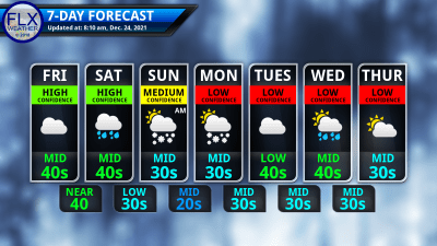
This graphic represents an average over the entire Finger Lakes region. Localized variations should be expected. Stay Updated With Email Alerts
Karen Merritt
Merry Christmas Drew, to you and your family.