


Summary of the Storm So Far—6:30 AM
A winter storm is ongoing across the Finger Lakes region this morning. Here are the latest developments.
The snow moved in quicker than expected last night. This is something that should have been anticipated, as I have noticed this as a trend with previous systems.
The early arrival allowed for some extra time of heavy snow before turning over to sleet during the overnight. Some areas have been able to exceed their snowfall forecast based on that factor alone.
The changeover to sleet looks as though it happened on schedule and to the extent I have been thinking for days.
Now, early this morning, the dry slot has moved in to cause an overall decrease in precipitation intensity with some large breaks where it is not precipitating at all. This, too, seems to be occurring as expected.
Heavy snow continues over western New York.
Overall, despite the early start, the forecast seems to be holding up fairly well overall. Every storm has its surprises, and no snow map can ever capture accumulations perfectly in every location… especially not in a low confidence situation like I have been stressing this one is.
What to Expect From Here
There should be little overall change in the conditions through the mid-morning hours. Snow will fall in the west, while precipitation will be on and off and mixed across the Finger Lakes.
During the later morning hours, as the low begins to pass us by to the east, snow will spread back across the area from the west. Some pockets of heavy snow will be possible through the early afternoon, especially in the northern half of the region where some extra moisture from Lake Ontario will be present.
By the mid afternoon, snowfall rates should begin to drop but wind speeds will increase. Northwest winds will gust between 30-35 mph, leading to blowing and drifting snow and continued reduced visibility. Travel conditions will remain tricky.
Additional snowfall through the afternoon will be 1-3 inches in the southern half of the region, and 2-4 inches in the northern half. Along the shore of Lake Ontario, and in far western areas that are continuing to see heavy snow this morning, localized amounts over 6 additional inches are possible.
Widespread storm snow will transition to bands of scattered lake effect snow this evening. The snow may especially concentrate over northern Cortland and Onondaga counties, where the rise in elevation will help enhance the snowfall.
Snowfall this evening and overnight will have localized accumulations up to two inches, except in Cortland and Onondaga counties as described above, where 3 or 4 inches could fall in a few places.

Beyond the Storm
Lake effect snow will wind down Tuesday morning and some breaks of sunshine will be possible for the afternoon. Temperatures will not change much during the day, starting generally around 20 degrees and reaching a high in the low 20s.
Northwest winds will still be on the blustery side, so areas of blowing snow will continue to be possible.
Wednesday looks mostly cloudy but warmer with gusty south winds. Higher elevations will be in the mid and upper 30s, while lower elevations push into the low 40s. A few rain and snow showers will move in after sunset, transitioning to some light snow Wednesday night as a cold front moves through.
Snow showers will continue into Thursday as temperatures drop. Most of the day will be spent in the mid teens.
Some lake effect will develop late Thursday, though Thursday night, and into early Friday. Accumulations should be minimal, but the clouds and snow will insulate the area against more frigid air. Areas that do not see lake effect clouds will probably drop below zero.
The lake snows will die off Friday, but cold air will remain with highs in the teens. Temperatures should return to the 20s for the weekend.
More Information:
» Finger Lakes Weather Radar
» Zip Code Forecasts
» Get the FLX Weather Mobile App
Get the latest forecasts delivered to your inbox automatically. This is the best way to ensure you are always seeing the newest information. Subscribing is easy, free, and secure. 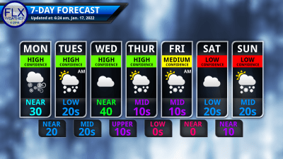
This graphic represents an average over the entire Finger Lakes region. Localized variations should be expected. Stay Updated With Email Alerts

Meteorologist Drew Montreuil
Thank you, everyone, for the reports!
Steve Barrows
Nine inches in Candor at 8:30. Occasional flurries since then. No detectable freezing rain or sleet, but it was slightly drizzly about 11:30.
Susan Eginton
I just downloaded your app, Drew! So glad to have that. It looks terrific!
David Jorgensen
6″ east of Ithaca, a depth that stayed the same after 2:30am despite the continued precipitation heavy in sleet then rain
Amy
9-12” in various spots, not counting drifts, midway between Lodi and Interlaken, 10:30 a.m.
Sarah Schantz
12″ on Newtown Road between Mecklenburg and Odessa. No ice! A bit higher elevation.
Susan Sarabasha
Tupper Rd Hill in (about 1500’) West Danby, Newfield has about 13” and no ice underneath.
Lynne
Tburg Village about 11 in.
michael whitted
8-12 at enfield/newfield line about stopped snowing
8:20
Erin S
12 inches 7:45am. Heavy snow, no sleet. Located on the Hector Backbone area. On the east side of Hector and SW of Trumansburg. North of Mecklenburg.
John Gregoire
11.5inches as of 0700 at Mecklenburg 4 SW. (4 miles SW Mecklenburg and the Schuyler Cty NOAA/NWS coop station. Not melted as yet for water equivalent.