


Warm Front-Cold Front
An area of low pressure tracking across Canada is bringing in some warmer air for a very brief stay.
Temperatures have risen significantly overnight, with many areas jumping from the single digits into the 20s and 30s.
South winds feeding into the center of low pressure will continue through the morning and early afternoon before turning to the southwest to end the day. Some of the winds will be blustery, especially early this morning over higher elevations, and later this afternoon along and west of I-390. Gusts of 30-40 mph will be possible.
Outside of the wind, it will be a rather quiet and dull day. Clouds will remain thick with only a few occasional glimpses of sunshine expected. A spit of rain or a few flakes may fly at any time, but the majority of the region will be dry throughout the day.
Temperatures will work into the low 40s for most lower elevations with upper 30s in the hills of the western Southern Tier and Central New York. Evening temperatures will initially only drop to the low and mid 30s.
By midnight, the cold front associated with the low will sweep through and temperatures will start to tumble. Temperatures will quickly fall through the 20s and into the mid and upper teens by daybreak.
Snow showers will become more common overnight. Most of these should be light and brief, so the chances of seeing an inch or more of accumulation are minimal.
Northwest winds will blow steadily through Thursday but gusts should stay under 30 mph. Some light lake effect flurries are likely downwind of Lake Ontario across the northeastern portions of the Finger Lakes. Daytime accumulations should not exceed an inch in most areas.
Temperatures will hold steady in the mid and upper teens on Thursday before dropping after sunset. The lake effect will intensify after sunset as well, with a couple inches falling Thursday night across Wayne, Cayuga, Onondaga, northern Cortland, northern Tompkins, and even portions of Seneca and eastern Ontario counties.

Long-Lasting Cold
The lake effect snow and clouds will prop temperatures up, holding most of the aforementioned areas between 0 and 5 degrees Thursday night. Areas outside of the lake effect will likely drop below zero, with lows mostly staying near or warmer than -5.
The lake snows will move west and dissipate Friday morning as high pressure moves along the US-Canada border in northern New York and New England. Sunshine will increase across much of the region, though a few clouds may linger near Lake Ontario and into the I-390 region.
High temperatures on Friday will only make it to around 10 degrees. Clear skies and nearly calm winds will allow for ideal nighttime cooling conditions Friday night. Widespread sub-zero temperatures are likely, and some areas could get into the negative teens.
Much of Saturday will be sunny with light winds under 5 mph. What wind there is will be from the south. Temperatures should warm into the upper teens for afternoon highs.
South winds will increase Saturday night and early Sunday, keeping overnight temperatures in the teens and pushing highs Sunday into the mid 20s. Lake effect snow will kick up again off the lakes as winds turn to the southwest, then west.
These winds will keep the snow out of the area initially, but the snow bands will pivot south and into the Finger Lakes Sunday afternoon and Sunday night. The snow will stick around into Monday but will be losing its intensity.
Overnight temperatures both Sunday night and Monday night will be into the single digits. Highs on Monday will be in the mid teens. Tuesday will have some sun and will approach 20 degrees.
Daytime temperatures are expected to stay near or under 20 degrees for most of next week with a couple more chances for subzero nighttime temperatures. A slight moderation to the cold is possible thereafter.
More Information:
» Finger Lakes Weather Radar
» Zip Code Forecasts
» Get the FLX Weather Mobile App
Get the latest forecasts delivered to your inbox automatically. This is the best way to ensure you are always seeing the newest information. Subscribing is easy, free, and secure. 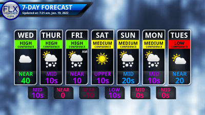
This graphic represents an average over the entire Finger Lakes region. Localized variations should be expected. Stay Updated With Email Alerts
