


Another Front Tonight
A strong area of low pressure is sitting well to our north over eastern Canada, spinning cold fronts through our area.
One such front was responsible for the steady rain yesterday afternoon, while a second, more subtle front moved through overnight.
Now, a small bubble of high pressure will slide through, leaving conditions for today mostly quiet, albeit a bit breezy.
West winds will blow at around 12 mph with gusts of 25-35 mph. The best chance for gusts over 30 mph will be near and west of Canandaigua Lake. A few gusts as high as 40 mph cannot be ruled out in those areas.
Skies will be sunny with a few fair-weather clouds bubbling up. Temperatures will rise into the mid 70s while dewpoints remain around 50 degrees.
Late this afternoon and early this evening, another cold front will drop southeast through the area. A few stray showers will be possible with this front. Most areas will not see rain, and the best chances for rain will be over the northern half of the region.
There is a minimal chance for lightning, gusty winds, and small hail with these showers, especially before or very close to sunset.
Winds will turn to the northwest early Thursday, possibly triggering a few stray lake effect rain showers southeast of Lake Ontario. These will be very sporadic and mostly in just the early morning hours. Wind speeds will go over 10 mph southeast of Lake Ontario during the morning hours before lessening for the afternoon.
Thursday should also have a good deal of sunshine with some fair-weather clouds mixing in. High temperatures will mostly be around 70 degrees, but pockets of upper 60s are likely, especially in the northeastern quadrant of the area.

Labor Day Weekend Weather
High pressure will pass overhead Thursday night, leading to clear skies and calm winds early, followed by a developing south wind after midnight. Temperatures will quickly drop into the 50s during the evening, but the freefall will be halted by the winds. Still, pockets of 40s will be possible along with widespread low and mid 50s overnight.
Friday will be mostly sunny with the high centered just to the east over New England. The south winds will push warmer air into the region, despite speeds only near or below 5 mph. Afternoon highs should jump about 10 degrees over Thursday, topping out around 80.
Even warmer air is expected on Saturday with highs pushing into the mid 80s. The south wind will be more substantial with speeds closer to 10 mph, especially over higher elevations. Skies will be a mix of sun and clouds with no rain expected.
A cold front will drop south on Sunday. Scattered showers and thunderstorms will develop, though the timing of the front will determine how much rain we can expect. Winds aloft look weak, so severe weather should not be a major threat.
The forecast is a bit less certain as we head into Labor Day and the back-to-school week that follows. Most likely, dry weather will continue to dominate. However, there will be some chances for rain, especially early in the week if Sunday’s front gets hung up nearby, and again later in the week.
For temperatures, early week highs should be in the lower half of the 70s behind Sunday’s front. The rest of the week will be a slow moderation towards highs pushing into the low 80s by the end of the week.
More Information:
» Finger Lakes Weather Radar
» Zip Code Forecasts
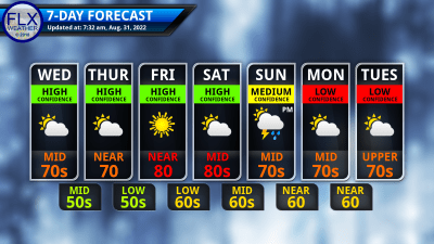
This graphic represents an average over the entire Finger Lakes region. Localized variations should be expected.
Get the FLX Weather App!
Take FLX Weather with you so you always have the latest weather information!
When you download, be sure to enable location services. The app will automatically display the forecast for your location. Plus, you can save several locations for quick and easy forecasts for around the region.
Other features on the app include an improved 7-day outlook, the latest blog post, radar, alerts, and a Live Updates feature.
The app is FREE on both Apple and Android, thanks to the generous financial support of my donors and sponsors. Search “Finger Lakes Weather”, or use the links here:
![]()
![]()