


Early Week Weather
An area of high pressure passed through our region last night, leading to some cold temperatures across the area.
During the predawn hours, however, temperatures were steady or rose a few degrees as winds turned to the south ahead of our next weather maker. This is an area of low pressure moving across southern Canada, which is currently located north of Lake Superior.
Warmer air pushing into the area has led to a few stray snow showers early this morning. Most areas will see little to no snow, and those that do should not see any accumulation. Outside of these flurries, skies will be generally cloudy but with some breaks and thin spots that allow for some limited sunshine.
Mostly cloudy skies will persist this afternoon, and a stray shower cannot be ruled out, especially late in the day. A few occasional breaks in the clouds will also continue to be possible.
Warm air will continue to push into the region but will not fully make it through. Afternoon highs will be in the low and mid 50s from about Seneca Lake westward, while to the east, mid and upper 40s are more likely.
The progression of the warmer air will be marked not only by a difference in temperature, but a difference in wind. In the warmer, western areas, the wind will be from the west with speeds up to 10 mph. Near the boundary between Keuka and Cayuga Lake, winds will be variable and light. Further east, winds will be from the south at around 5 mph.
Tonight, a cold front will move through the area. Scattered showers will develop ahead of the front, and lake effect showers will develop in its wake. Between midnight and dawn, winds will be from the northwest with speeds around 10 mph.
With overnight temperatures in the mid and upper 30s, a few of the showers may mix with or turn to flurries.
Scattered showers and a few flurries will persist into Tuesday morning but should gradually diminish and disappear. Some late day sun may even be possible.
Temperatures on Tuesday will mark the low point for daily highs this week with most areas in the mid and upper 40s.

Warmer, Quiet Weather
Partly cloudy skies will lead to temperatures in the upper 20s and low 30s Tuesday night. However, winds will turn to the south after midnight and some thin clouds will begin to move into the region.
Thin clouds will persist through Wednesday, filtering the sunshine but probably not completely blocking it out. No precipitation is expected.
South winds will persist through the day, pushing temperatures up. Upper 50s are possible near Rochester and in the Genesee Valley. Mid 50s are likely for most other lower elevations, with hilltops in the low 50s. The Cortland area may top out around 50 degrees.
Skies will clear Wednesday night, but southwest winds will hold temperatures in the 30s. Thursday will follow with lots of sunshine and mild temperatures. Even higher elevations should be in the mid 50s, while some of the warmer valley locations may push 60 degrees.
Southerly winds will increase to around 10 mph on Friday, but so too will clouds increase. This will be in response to the next weather system, which will spread some rain showers into our area on Friday evening. High temperatures will be closer to Wednesday’s highs than Thursday’s.
The weekend should see temperatures knocked back to the 40s with some occasional showers as winds turn to the northwest.
Temperatures will most likely stick to the 40s for most of the week of Thanksgiving next week. Precipitation looks especially likely in the Tuesday-Wednesday time frame of next week.

More Information:
» Finger Lakes Weather Radar
» Zip Code Forecasts
» Get the FLX Weather Mobile App
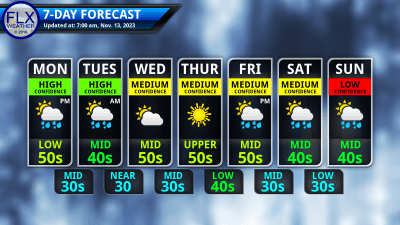
This graphic represents an average over the entire Finger Lakes region. Localized variations should be expected.
Business Sponsors Needed
Do you run a local business in the Finger Lakes? Consider sponsoring Finger Lakes Weather and gain new exposure to a captivated local audience.
Finger Lakes Weather has a limited opportunity for new sponsors, which play a vital role in funding my operations. With annual views of over 600,000, sponsors enjoy unparalleled cost-effective local reach. Sponsorship rates have remained unchanged for years, and many sponsors continue their support year after year.
For more information on the Sponsorship Program and to claim one of the limited number of available spots, check out the Sponsorship page right away!