


Approaching Storm System
A southerly flow of warmer air will move into the Finger Lakes today despite persistent clouds.
As the warm air moves in, it is trapping some moisture in the lower levels of the atmosphere, leading to thick clouds this morning. No precipitation is falling from the clouds, though.
Much of the day will end up cloudy, though some breaks of sun will start to penetrate the overcast during the afternoon hours. Even so, new clouds out ahead of the next weather maker will already be moving in aloft.
The wind today will be light, coming in around 5 mph with gusts mainly under 20 mph. Much of the region should get to or above 55 degrees as a result. The light winds will allow a lake breeze off Lake Ontario to set up, so coastal areas will be cooler.
The warmest areas will be along I-390 south of Rochester, and throughout the southern half of the region, where upper 50s will be possible.
A few spits of drizzle will become possible after midnight with rain moving into the Southern Tier Thursday morning. Steady rain should make it to about the I-90 corridor by Thursday afternoon, but areas north of that may just see a few on and off rain showers.
Cooler and drier air will move in from the north late Thursday. Rain will most likely turn to snow first in the higher elevations of the western Southern Tier during the afternoon. From there, it will be a race between a transition to snow and the end of the precipitation.
The most likely scenario will be for accumulating snow to be limited to the counties that border Pennsylvania. The hills of Allegany and Steuben county have the best shot at several inches. Lower elevations further east, like Elmira and Binghamton, have a lower chance at accumulations, but could still find themselves with an inch or two of slushy snow Thursday evening.
Little to no snow accumulation is expected at this time for counties that do not border Pennsylvania, except maybe over the higher elevations of Schuyler and southern Tompkins and Cortland counties.

Chilly Friday, but then Turning Warm
Behind this weather system, blustery north winds will set up for Friday. Morning lows will start in the upper teens, and afternoon highs will struggle into the low 30s.
Winds will start to gust over 30 mph before the sun rises Friday and will continue throughout the morning. A gradual decrease in winds is expected for the afternoon, but gusts may still be over 25 mph for the southeastern Finger Lakes until sunset.
Beside the wind, Friday will be quiet with plenty of sunshine and no precipitation.
The center of high pressure will move through the area on Saturday, removing the influx of cold air from the north. With light winds and ample sunshine, temperatures will quickly start a warming trend.
Morning lows Saturday will still be well into the 20s, but afternoon highs should reach the low 50s for many areas. From there, it is only up.
Sunday will top out in the upper 50s to near 60. Monday will break into the low 60s. By Tuesday, mid 60s are possible.
There is a bit more uncertainty in the temperatures for the latter half of next week, but highs should stay at least in the 50s and could actually turn out even warmer than the first half of the week.
Ample sunshine is likely Sunday into Monday with just a few clouds Tuesday. Again, the later half of the week is less certain., but we should at least stay dry until later Thursday or Friday.
Conditions during this dry, sunny, warm stretch will be ideal for brushfires thanks to very low humidity levels. The annual NYS burn ban is in effect. Early Spring is our fire season, and this stretch of weather looks particularly prone. The only ingredient missing for a serious concern will be winds, but please respect the burn ban.
Final Note – Major Tornado Outbreak
A major outbreak of severe thunderstorms, including long-lived, violent tornadoes, is expected to unfold today and continue into Thursday.
The Storm Prediction Center has issued a high risk for severe thunderstorms, centered on central Mississippi today. This is the first high risk issued since May 2019, when the one and only high risk of that year was issued.
Tomorrow, a moderate risk is issued across the Carolinas, though time will tell whether this needs upgrading as well.
This is a textbook outbreak of severe weather and tornadoes for these areas. If you have friends or family in these areas, checking up on them this morning to make sure they know of the risk and have an action plan in place would be prudent.
It is hard to see these situations, even from afar, knowing that no matter how good the forecasts are and how much lead time the warnings give, not everyone is going to make it through the next 48 hours ok. My thoughts and prayers are with everyone impacted by this severe weather outbreak.

 A tornado outbreak is likely today across the Deep South, centering on central Mississippi. Numerous long lived, violent tornadoes are possible.
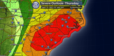 Severe weather, including strong tornadoes, will continue into Thursday as the focus shifts to the Carolinas.
More Information:
» Finger Lakes Weather Radar
» Zip Code Forecasts
Get the latest forecasts delivered to your inbox automatically. This is the best way to ensure you are always seeing the newest information. Subscribing is easy, free, and secure.

This graphic represents an average over the entire Finger Lakes region. Localized variations should be expected. Stay Updated With Email Alerts
Valerie
I’m with you there regarding the tornado outbreak. While these things are exciting to track, the words of my Atmospheric Processes professor come back to me: “There are people out there who don’t know that they will die today.” I hope and pray that many people have adequate shelter and that we will not see a death toll today/tomorrow.