


Cool and Unsettled
A meandering low pressure that has kept our weather unsettled for days has finally made it into far eastern Canada while a sprawling high pressure has built into the Midwest and Upper Great Lakes.
Between these two systems, winds have turned to the northwest across the Finger Lakes. With plenty of moisture and cool air still lingering behind the low, conditions are favorable for more lake effect rain showers.
Scattered showers are currently spread across the region this morning, favoring the eastern half of the area as is typical for lake effect on a northwest flow.

As daytime heating kicks in, the showers should become more cellular instead of clusters or bands of rain. The showers will also spread throughout the region, bringing on and off rain to most areas. A rumble of thunder or some small hail cannot be ruled out thanks to the cold air aloft.
Between showers, some breaks of sun will be possible. Temperatures will mostly be held to the mid 50s, though a few areas may sneak into the upper 50s, especially if the sun outweighs the showers for a period of time.
Winds will remain from the northwest throughout the day with speeds around 10 mph. Top gusts will be between 20-25 mph.
The coverage of the showers will diminish after sunset, but spits of rain will continue through the night and into Thursday morning. The clouds and persistent breeze overnight will hold temperatures in the 45-50 degree range for most areas. A few locally colder pockets will be possible, especially in the Southern Tier, where the influences from Lake Ontario will be lessened.
Spits of rain and drizzle Thursday morning will gradually dry up and sunshine will eventually increase as the high pressure draws near. North-northwest winds up to 10 mph will keep temperatures in the mid 50s.

Drying Out
High pressure will build in overhead Thursday night with calm winds and clear skies. This will make for ideal radiational cooling conditions, resulting in a cold and frosty night.
Many areas are expected to reach the mid 30s, which means pockets of low 30s or even some upper 20s are not unreasonable to expect. Even some less protected lake shore areas may dip into the upper 30s.
Frost and localized freeze conditions are likely. As usual, localized topographical influences will dominate, so knowing if your exact location frosts easily or not is an important consideration.
Sun-filled skies Friday morning should help temperatures warm quickly, though winds will remain nearly calm or very slight out of the north. Afternoon highs should be into the low 60s.
Late in the day, thin overcast on the leading edge of Hurricane Ian will make its way into our region. These clouds will help keep temperatures Friday night from getting too low, with mid 40s likely overnight.
The clouds will stick around throughout Saturday and may even thicken up further. However, no rain is expected and highs should still reach the mid 60s.
By Sunday, the clouds are expected to break up as Ian loses tropical characteristics over the southern Appalachian Mountains. Look for a mix of sun and clouds across the Finger Lakes with highs in the mid 60s.
More of the same is likely for Monday and Tuesday next week, though there remains an outside chance for a few showers from the remains of Ian. Most likely, however, no rain from Ian will make it this far north with high pressure blocking its way.
A cold front will finally bring rain back into the forecast towards next Thursday with a brief shot of cool air.
A quick note on Hurricane Ian. Ian will make landfall in western Florida this morning as a catastrophic category 4 hurricane, though a brief intensification to category 5 status is not out of the realm of possibility.
This is obviously a tragic disaster unfolding. My thoughts and fervent prayers go out to all affected, including people I know personally who will be in some of the worst of the storm today.
More Information:
» Finger Lakes Weather Radar
» Zip Code Forecasts
» Get the FLX Weather Mobile App
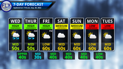
This graphic represents an average over the entire Finger Lakes region. Localized variations should be expected.
Weather Calendar Photos Needed!
Have you captured the beauty of the weather in the Finger Lakes with a picture in the last year? Now is your chance to be featured on the brand new FLX Weather Calendar! Now accepting photos of all weather types and all seasons through October 10th. Just fill out the easy uploader form to submit your entries. » Submit your photos here! «