


Wind Advisories
The low pressure system that brough the rain to the Finger Lakes yesterday is now just off the New England coast.
The low will slowly track northward today and will continue to control our weather.
The biggest impact from the low will be strong winds today. Wind Advisories are in place for most of the region. An advisory is less serious than a High Wind Warning would be.
Winds will come from the northwest today with frequent gusts over 45 mph. The strongest gusts of around 55 mph will be over higher terrain. A few sporadic power outages and downed trees will be possible.
Precipitation will be spotty at best for much of the day. Bits of drizzle and brief showers will still be possible but will be isolated. A few breaks of sunshine will be possible as well, especially this morning.
Temperatures will reach their high point during the midday hours near or just above 50 degrees. A slow but steady drop into the 40s is expected for the afternoon.
Late this afternoon and this evening, moisture and energy wrapping around the low will press into the region from the north. By this time, temperatures will be falling into the upper 30s, first over higher elevations.
Precipitation will increase, possibly starting as some rain but turning to snow. The snow may come down steadily for a few hours this evening. Accumulations will be limited to grassy surfaces, but some higher elevations could see an inch or two.

Warming Back Up
By Saturday morning, skies should be mostly clear with morning lows near or just above the freezing mark. Temperatures will quickly warm thanks to the bright sunshine. Any snow that accumulates overnight will not last the morning.
Winds will turn to the southwest during the day Saturday, helping push temperatures into the upper 50s for many areas. Some clouds and a few scattered showers will move in late in the afternoon.
Saturday night will be much warmer with overnight lows in the low 50s. Sunday will continue the warming trend, with highs in the upper 60s. Some places will probably hit 70 degrees.
Scattered showers will continue to be possible on Sunday, though much of the day will be dry.
Rain chances will increase later on Monday and into Tuesday as a weather system moves through. Temperatures will remain warm, with daytime highs in or near about the upper 60s.
A second system will move in on Wednesday with the potential for more widespread rain. This far out, though, the chances remain highly uncertain.
A quieter and cooler end to next week is expected with highs retreating towards the 40s and low 50s for Thursday and especially Friday and Saturday. Temperatures should only stay down a couple days, though.
More Information:
» Finger Lakes Weather Radar
» Zip Code Forecasts
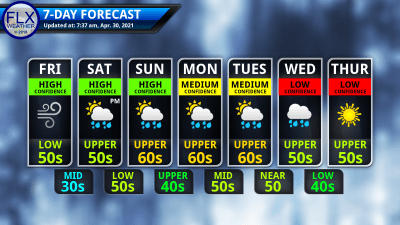
This graphic represents an average over the entire Finger Lakes region. Localized variations should be expected.
